Fly!
Terrascene 2
2000
FlyingSinger reported :
The Quabbin Reservoir is a few minutes west of Worcester, Massachusetts (ORH) and is one of my frequent flying practice areas. It's a large, man-made lake with a complex shoreline and many islands. It's also quite scenic.
Recently I learned about a brand-new version of the How In The World's TerraScene (version 2 - see FLY! links) scenery generation software for FLY! Since my "old" scenery ended just west of ORH, I decided to try out TS2 and see how it would do with the Quabbin.

Well, it took the better part of a night, but it did a great job with next to zero effort by me! I used the new TS2 scenery wizard and told it I wanted an area 30 nm around ORH. That was about it (I took default settings on just about everything else). The program figured out the data that it needed and automatically downloaded the terrain and feature data from the USGS web site. It then parsed and processed for some 12 hours (on my P400 with 192 MB) to create two large .TGA files (day and night) which look like aerial photos of my flying area. I made an error which prevented the program from importing the scenery into FLY! (I failed to install the provided 1.06 beta version of FlyEdit into the FLY! directory). This just meant that I had to run the editor myself so FLY! could import the scenery.
The results are great!
Here is a photo I took over the Quabbin last August:
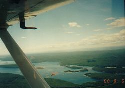 Quabbin Reservoir - Massachusetts
And here are two shots of the same area with my new Quabbin scenery in the C172 in FLY!
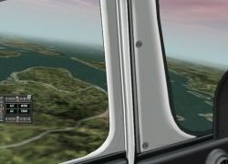 Quabbin Reservoir - Massachusetts - rendered into FLY using Terrascene
 Quabbin Reservoir - Massachusetts - rendered into FLY using Terrascene
If you look carefully, you can spot some of the islands in the real photo in the FLY! screen shots. The shapes and positions are just right. One thing I need to revisit is elevation data. By messing up TS2's final step, I think I lost the chance to use the downloaded USGS digital elevation maps (DEM), reverting to the lower-rez default terrain height data from FLY! instead.
I'm guessing that TS2 will let me rerun this final step without much trouble (I haven't read any doc yet, of course, but when someone picked up the phone during a USGS download, the procedure started right up again without a hitch).
Quabbin Reservoir - MassachusettsThis is amazing stuff -- Todd Klaus has created a great upgrade to an already excellent product. And did I mention that it is freeware? Just make sure you have a lot of free disk space and a reliable net connection -- the data and graphic files for this stuff can be huge (though a lot depends on how large a region you choose to render).