
Australia | Missions in the MiGMan’s World Tour DLC
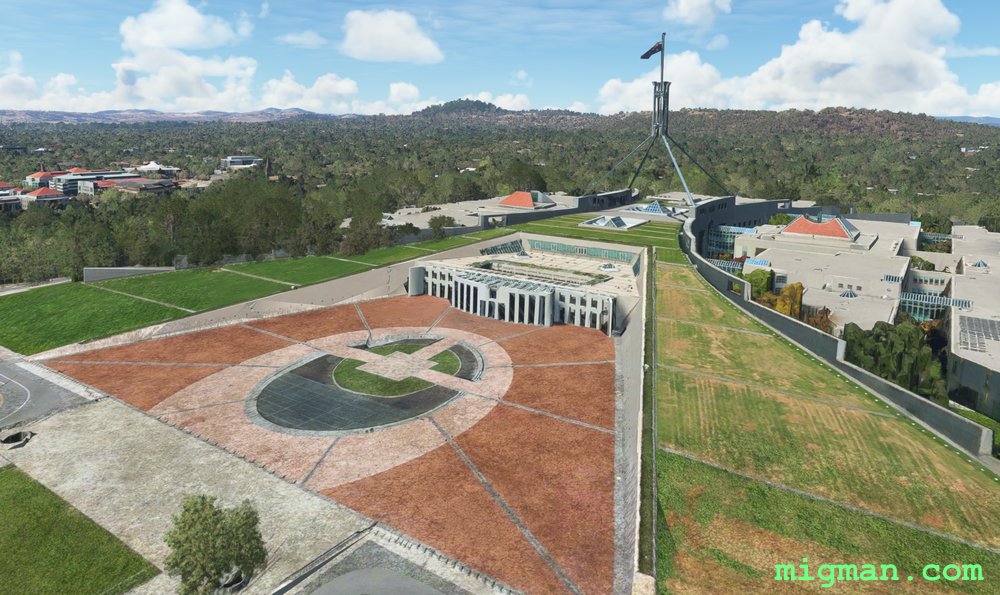
Canberra by Burley Griffin
AboutCanberra, being populated totally by government administrators, is about Kafkaesque a city as you would expect. For example, the tourist bureau is not open on Tuesday. Why?
Canberra is located quite literally in the middle of nowhere and away from all centres of trade and economic production, the result of a compromise between putting the seat of Australia’s government in Melbourne or Sydney. The compromise was not exact, as it is 287 km from Sydney and 663 km from Melbourne, which seems fair.
Physically it is quite charming, albeit totally confusing due to the circular road networks around the centrepiece that is Lake Burley Griffin. Said lake is named after the American architect who won an international competition in 1912 and designed Canberra. I’m sure it made complete sense on paper.
Australia
location_cityA.C.T. (Australian Capital Territory)
flight_takeoffYSCB Canberra
airline_seat_recline_extraAustralia 1
tagDam spotting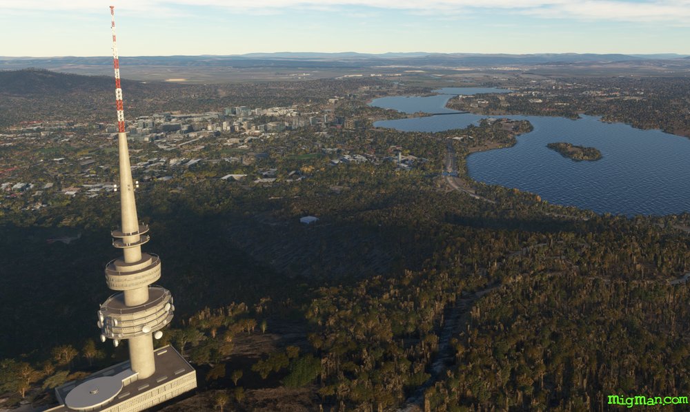
Black Mountain Hop
AboutBlack Mountain, so named because it is barely a mountain and not black, is nonetheless the most prominent landmark in Canberra. You will find it at the NW corner of Lake Burley Griffin and it features the distinctive Telstra Tower at the 2,664 ft summit. NOTAM: Canberra airport elevation is 1,869 ft so cruise at 3,000 ft above sea level.
Australia
location_cityA.C.T. (Australian Capital Territory)
flight_takeoffYSCB Canberra
airline_seat_recline_extraAustralia 1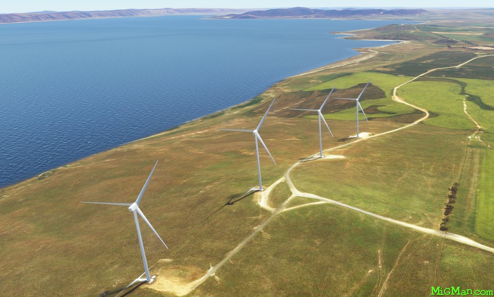
King George
AboutFollow the King's Highway east out of Canberra and then fly over Lake George, the largest body of water near the A.C.T. I like to alternate my flights over Lake George between the wind farms on the eastern shore and the following the base of the ridge on the western shore. George V was monarch of the United Kingdom and the British Commonwealth until 1936.
NOTAM: Canberra airport elevation is 1,869 ft so cruise at 3,000 ft above sea level.
NOTAM: Canberra airport elevation is 1,869 ft so cruise at 3,000 ft above sea level.
Australia
location_cityA.C.T. (Australian Capital Territory)
flight_takeoffYSCB Canberra
airline_seat_recline_extraAustralia 1
tagBridges
tagAiports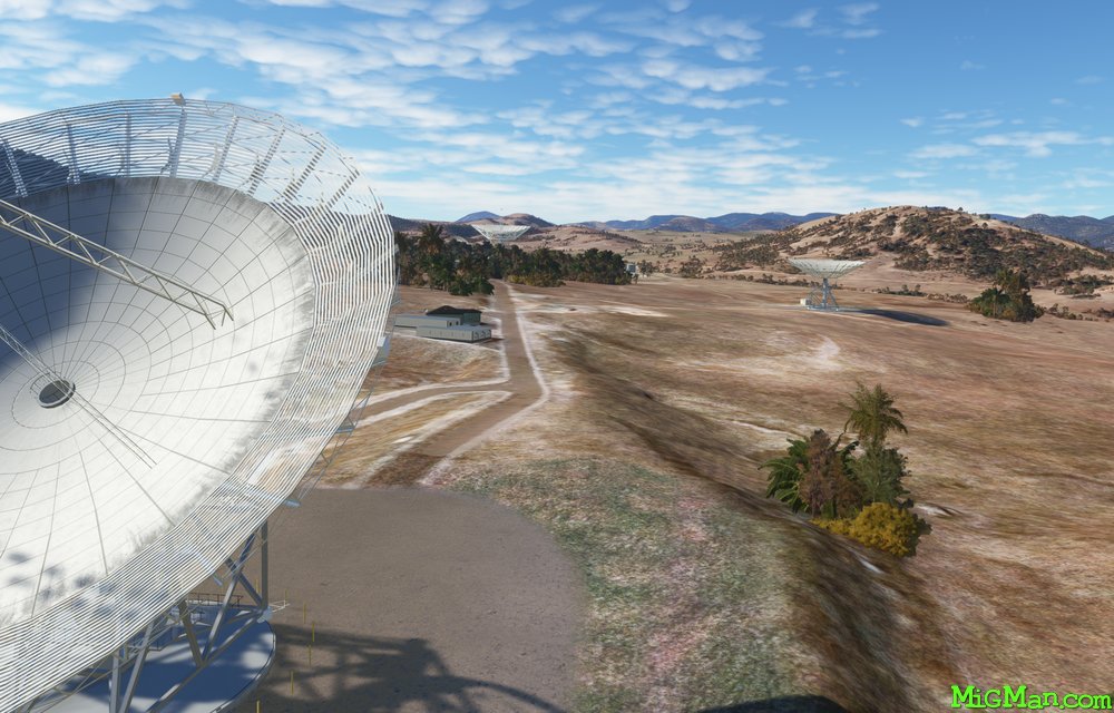
Dams and Deep Space
AboutVisit the four dams which service Canberra and Queanbeyan, and the Canberra Deep Space Communication Complex.
NOTAM. Canberra airport elevation is 1,869 ft so cruise at 3,000 ft.
NOTAM. Canberra airport elevation is 1,869 ft so cruise at 3,000 ft.
Australia
location_cityA.C.T. (Australian Capital Territory)
flight_takeoffYSCB Canberra
airline_seat_recline_extraAustralia 1
tagDam spotting
tagCanyon runs & Mach Loops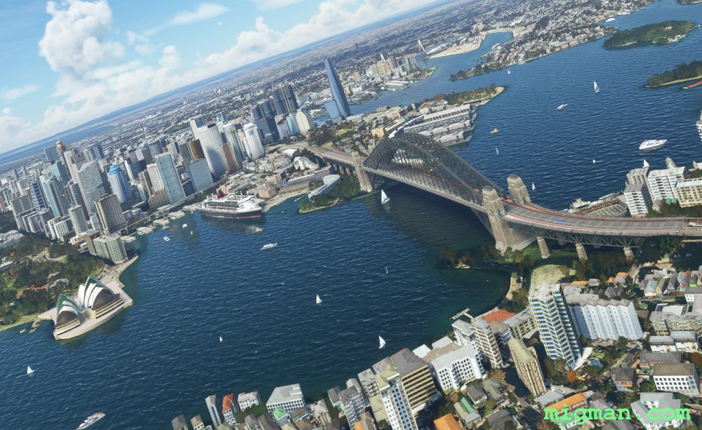
Sydney's Northern Beaches
AboutFly out of Sydney's second largest airport at Bankstown, and use Sydney Olympic Stadium as a turnpoint onto the Parramatta River. Along Sydney Harbour and past the Sydney Opera House. Then turn north and follow the low level route along the beautiful northern beaches. Keep a look out for Great Whites and Budgie Smugglers.
Australia
location_cityN.S.W. | Sydney & Surrounds
flight_takeoffYSBK Bankstown
airline_seat_recline_extraAustralia 1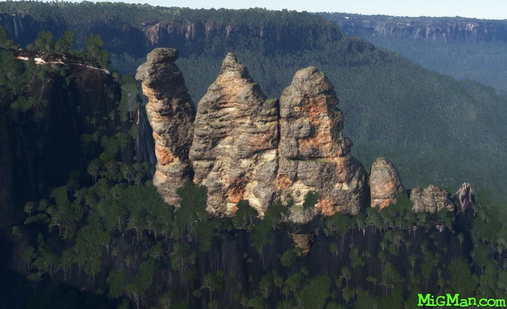
Three Sisters and Warragamba Dam
AboutFly into the Blue Mountains and check out the world famous rock formation 'The Three Sisters' at Katoomba in the Blue Mountains and return to Sydney via the Warragamba Dam.
Australia
location_cityN.S.W. | Sydney & Surrounds
flight_takeoffYSBK Bankstown
airline_seat_recline_extraAustralia 1
tagBridges
tagDam spotting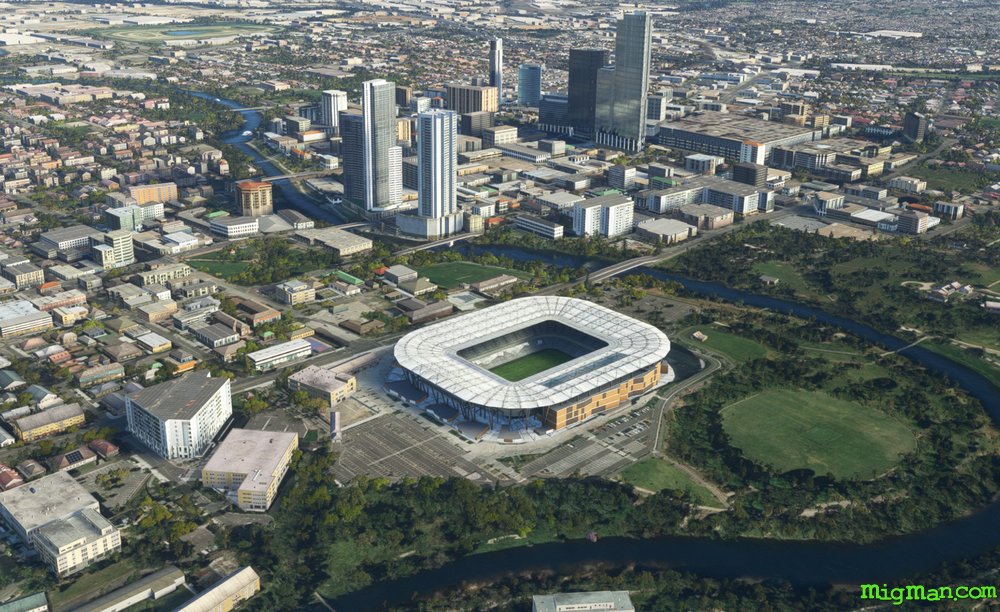
Parramatta, Birthplace of the Eels
AboutParramatta was the food basket of Sydney in the early days after 1788 due to the fertile soil and connection with the first settlement in Sydney via the Parramatta River. Parramatta Football Stadium is home of the Parramatta Eels Rugby League Club.
The last waypoint, Gladesville Bridge, is used as a visual reference for pilots approaching YSSY RWY 16 R from the north, which includes most inbound international traffic. The airport has curfews due to noise limits in the suburbs to the west, which somewhat limits it's efficiency.
The last waypoint, Gladesville Bridge, is used as a visual reference for pilots approaching YSSY RWY 16 R from the north, which includes most inbound international traffic. The airport has curfews due to noise limits in the suburbs to the west, which somewhat limits it's efficiency.
Australia
location_cityN.S.W. | Sydney & Surrounds
flight_takeoffYSBK Bankstown
airline_seat_recline_extraAustralia 1
tagBridges
tagAiports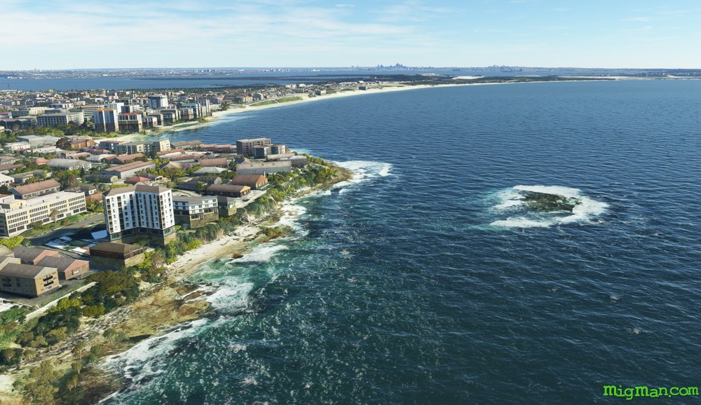
Scouting by Sea and Air
AboutCamden Airport is bordered on three sides by the Nepean River and is the Boy Scouts air activity base. I have seen everything there from gliders to L-39 Fighter Jets! Grays Point is on the northern edge of the Royal National Park. I suggest flying at low level along the bends of the Hacking River before turning north past Cronulla Beach.
Botany Bay is where Captain James Cook first stepped ashore from HMS Endeavour on April 29th 1770. Initially thinking this to be a suitable site for the 1st settlement, he changed his mind upon sailing 10 miles north to the mouth of what became Sydney Harbour.
Botany Bay is where Captain James Cook first stepped ashore from HMS Endeavour on April 29th 1770. Initially thinking this to be a suitable site for the 1st settlement, he changed his mind upon sailing 10 miles north to the mouth of what became Sydney Harbour.
Australia
location_cityN.S.W. | Sydney & Surrounds
flight_takeoffYSCN Camden
airline_seat_recline_extraAustralia 1
tagAiports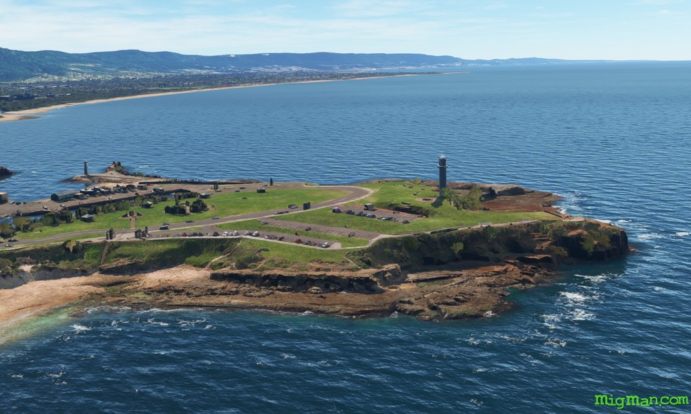
The Gong
AboutVisit 'The Gong' (Wollongong), home to Aunty Jack and the Port Kembla Steelworks, both icons to the post-boomer generation of Aussies. It was a simpler world back then with irreverant humour and school trips to the most dangerous workplaces. Great fun. Loiter over Wollongong and check out the steelworks. Then travel up one what is probably the most beautiful parts of Australia's east coast to Sydney's eastern suburbs. At Bondi Beach you will see lots of Poms and Kiwis mixing it up with the Great Whites. Just when you think it couldn't get any better, turn into Sydney Harbour and pass the Opera House and Harbour Bridge.
Australia
location_cityN.S.W. | Sydney & Surrounds
flight_takeoffYSCN Camden
airline_seat_recline_extraAustralia 1
tagCoastal flight
tagDam spotting
Kangaroo Valley
AboutTake a plunge off Fitzroy Falls into Kangaroo Valley in this dramatic flight. Head back to the coast and fly north past the famous Kiama Blowhole. All these locations are favourite day-trips for Sydney-siders. At the north west corner of Lake Illawarra you find a large Buddhist Temple on the Princes Highway which runs all the way from Sydney to Melbourne.
Australia
location_cityN.S.W. | Sydney & Surrounds
flight_takeoffYSHL Shellharbour
airline_seat_recline_extraAustralia 1
tagCoastal flight
tagCanyon runs & Mach Loops
Ulladulla, Sussex Inlet, Jervis Bay and Shoalhaven Heads
AboutFly south over the rugged terrain of the Yerriyong State Forest and Morton National Park, then return along the coast.
Speaking Astrayan: Let's head down the south coast for the weekend, is a phrase often heard in Sydney households. Although it may sound to the outsider like "Wanna go downa coast? We'll avagoodweegend!"
Round trips from north to south: 21 nm HDG 025: Jaspers Brush Airfield YBEY (3344 ft) 12 nm HDG 032: Bomaderry 24 nm HDG 057: Shoalhaven Heads 16 nm HDG 125: Huskisson on Jervis Bay. 28 nm HDG 130: Jervis Bay Military YJBY and Royal Australian Navy (RAN) base HMAS Creswell. 40 nm HDG 185: Mouth of Lake Conjola at WP 3 28 nm HDG 171: Swan Lake and Sussex Inlet 52 nm HDG 190: Ulladulla, at WP 2, has been a fishing town and popular recreational area since the 19th century.
Australia
location_cityN.S.W. | Sydney & Surrounds
flight_takeoffYSNW Nowra Military
airline_seat_recline_extraAustralia 1
tagBridges
tagCoastal flight
tagAiports
Lithgow
AboutLithgow was the site of Australia's first steel mill and is often considered to be the first country town west of Sydney. There are active mines and power stations nearby.
Fly loosely along the two main routes over the Blue Mountains from Sydney, west along the Great Western Highway and east along Bells Line of Road. It's always worth another flight to the Three Sisters. At the Three Sisters keep a sharp lookout for other traffic, as sightseers often approach along the valley from the west. The Great Western Highway continues past Blackheath and beyond Lithgow. The Hanson Clarence Quarry supplies sand, concrete ingredients and stone. Bells Line of Road passes the popular tourist spots of Mt. Wilson, Mt. Tomah Botanical Gardens and Appin, although they are not particularly easy to pick out from the air.
Australia
location_cityN.S.W. | Sydney & Surrounds
flight_takeoffYSRI RAAF Base Richmond
airline_seat_recline_extraAustralia 1
tagCanyon runs & Mach Loops
tagAiports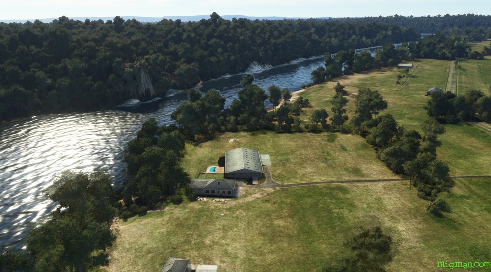
Broken Bay, Wiseman's Ferry and the Hawkesbury River
AboutThis flight covers the entire north west of the greater Sydney basin. Hornsby is the largest centre in Sydney's north. Bobbin Head is a mecca for picnics and water activities. Lion Island is the dominant landmark at the entrance to Broken Bay, so named because it resembles a lion recumbent. Wisemans Ferry features a car ferry which is the only way to cross the Hawkesbury River in this area.
Australia
location_cityN.S.W. | Sydney & Surrounds
flight_takeoffYSRI RAAF Base Richmond
airline_seat_recline_extraAustralia 1
tagBridges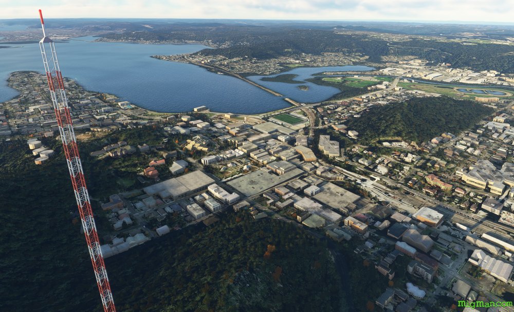
The Central Coast
AboutJust to the north of Sydney, across Broken Bay lays a fantasmagoria of beaches and lakes. Known locally as "The Central Coast", this area has always been a favoured holiday destination for Sydney-siders. Many locals commute to Sydney by train, and you can see the rail bridge about 4 nm west of WP 4, Lion Island. Round trips: 50 nm: Entire route, 7 nm: Mardi Dam HDG 190, 25 nm: Gosford
Australia
location_cityN.S.W. | Sydney & Surrounds
flight_takeoffYWVA Warnervale
airline_seat_recline_extraAustralia 1
tagBridges
tagCoastal flight
tagDam spotting
Lake Macquarie
AboutThe Newcastle and Hunter region includes Bulahdelah, Broke, Cessnock, Dungog, Maitland, Nelson Bay, Newcastle, Scone and Taree.
Take off from RAAF Base Williamtown and explore the water wonderland that is Lake Macquarie.
Take off from RAAF Base Williamtown and explore the water wonderland that is Lake Macquarie.
Australia
location_cityN.S.W. | Newcastle & Hunter
flight_takeoffYWLM Williamtown Military
airline_seat_recline_extraAustralia 1
tagDam spotting
tagAiports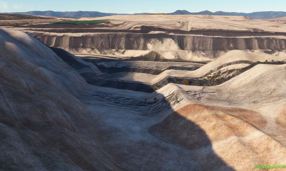
Cessnock, Singleton and Mount Thorley Warkworth Mine
AboutExplore the enormous open cut coal mine, Mount Thorley Warkworth Mine, near Singleton in the Newcastle & Hunter region of N.S.W..
Australia
location_cityN.S.W. | Newcastle & Hunter
flight_takeoffYCNK Cessnock
airline_seat_recline_extraAustralia 1
tagBridges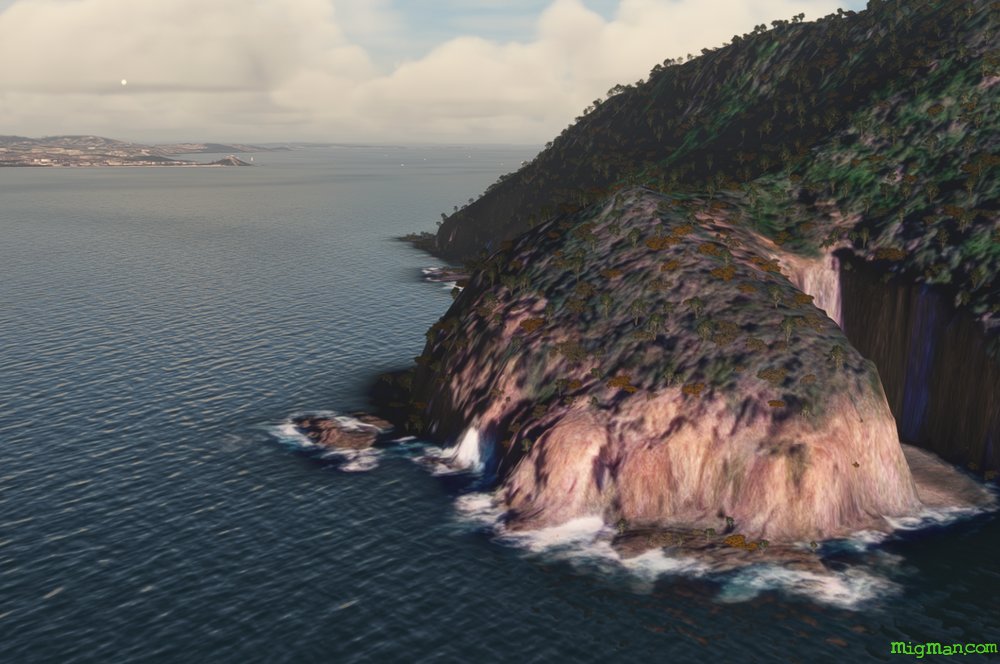
Port Stephens and Nelson Bay
AboutPort Stephens is a large harbour north of Newcastle, and Nelson Bay is the main tourist destination, popular for whale and dolphin watching tours.
Australia
location_cityN.S.W. | Newcastle & Hunter
flight_takeoffYWLM Williamtown Military
airline_seat_recline_extraAustralia 1
tagBridges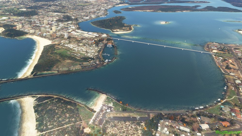
Forster and Tuncurry
AboutForster and Tuncurry guard the entrance to a complex series of lakes. The three main lakes to the south are Wallis Lake. Smith's Lake and Myall Lake. In this flight take the coast south and return inland along the Pacific Highway.
Australia
location_cityN.S.W. | Newcastle & Hunter
flight_takeoffYFST Forster
airline_seat_recline_extraAustralia 1
tagCoastal flight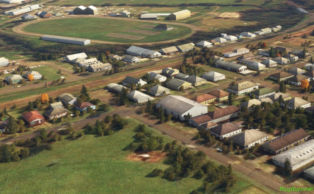
Taree and the Old Bar Airmail
AboutTaree is an agricultural centre near the east coast of N.S.W. which was settled in 1831. In the 1920s George Bunyan built the Old Bar Airfield for Australia's earlist passenger and airmail services.
Australia
location_cityN.S.W. | Newcastle & Hunter
flight_takeoffYTRE Taree
airline_seat_recline_extraAustralia 1
tagBridges
tagCoastal flight
tagAiports
Horse Capital of Australia: Scone
AboutVisit the second-largest horse breeding area in the world, after Kentucky USA.
Airports enroute: Quirindi Aerodrome YQDI
Entire route: 85 nm
Shorter return flight: 40 nm | Nowland's Gap
Airports enroute: Quirindi Aerodrome YQDI
Entire route: 85 nm
Shorter return flight: 40 nm | Nowland's Gap
Australia
location_cityN.S.W. | Newcastle & Hunter
flight_takeoffYSCO Scone
airline_seat_recline_extraAustralia 1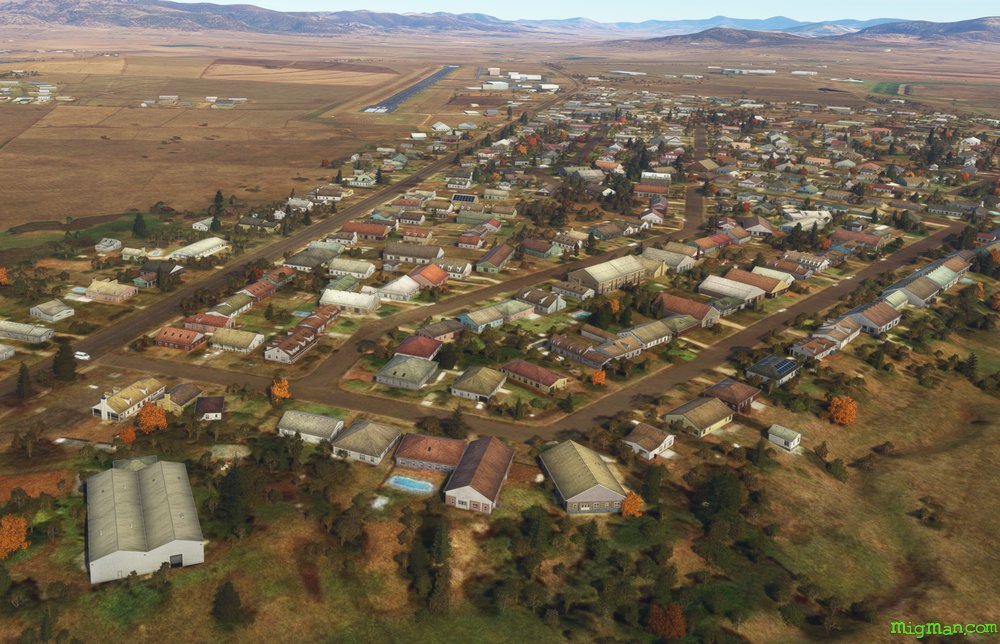
Scone SE: Lakes, Dams and Mines.
AboutIn the area bounded by Muswellbrook, Singleton and Lake Saint Clar lay Drayton, Liddel, Mount Thorley and a host of other large open cut coal mines.
Areas to explore: The vast complex of mines and processing plants south of Muswellbrook, between WP 1, 2 and 3. Lake Saint Clair at WP 3.
Entire route: 87 nm Shorter return flights: 19 nm | Lake Glenbawn at WP 4 28 nm | Muswellbrook
Areas to explore: The vast complex of mines and processing plants south of Muswellbrook, between WP 1, 2 and 3. Lake Saint Clair at WP 3.
Entire route: 87 nm Shorter return flights: 19 nm | Lake Glenbawn at WP 4 28 nm | Muswellbrook
Australia
location_cityN.S.W. | Newcastle & Hunter
flight_takeoffYSCO Scone
airline_seat_recline_extraAustralia 1
tagDam spotting
Port Macquarie and Comboyne Plateau
AboutExperience the highs and lows of this fertile region on the NSW coast.
Region: N.S.W. North Coast
Comboyne, population 454, is in the centre of a plateau notable for it's lush landscape and avocado farms.
Wauchope is home to "Timbertown Heritage Theme Park". At 87 acres, it is a sprawling recreation of the pioneering days of the timber industry in Australia. IT features a working steam train and blacksmiths.
Entire route: 70 nm Return flights. 12 nm: WP 7: Wauchope | 24 nm: WP 2: Laurieton and Queens Lake | 46 nm: WP 5: Comboyne
Australia
location_cityN.S.W. | North Coast
flight_takeoffYPMQ Port Macquarie
airline_seat_recline_extraAustralia 1
tagBridges
tagCoastal flight
tagCanyon runs & Mach Loops
Kempsey, Slim Dusty and the Akubra
AboutKempsey is the birthplace of Australian country music legend Slim Dusty, and also of that iconic Aussie hat, the Akubra.
Australia
location_cityN.S.W. | North Coast
flight_takeoffYKMP Kempsey
airline_seat_recline_extraAustralia 1
tagBridges
tagCoastal flight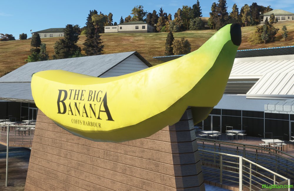
Coffs Harbour, Big Banana and Dorrigo
AboutFly out of Coffs Harbour, south along the coast and then inland to Dorrigo Plateau. Contrast the rugged bushland in the valleys on your right with the lush rolling famlands of the plateau on your left.
The Big Banana was built in 1964 to promote a roadside fruit stall and now hosts the largest water theme park between Sydney (NSW) and the Gold Coast in Queensland.
The Big Banana was built in 1964 to promote a roadside fruit stall and now hosts the largest water theme park between Sydney (NSW) and the Gold Coast in Queensland.
Australia
location_cityN.S.W. | North Coast
flight_takeoffYCFS Coffs Harbour
airline_seat_recline_extraAustralia 1
tagCoastal flight
tagDam spotting
tagCanyon runs & Mach Loops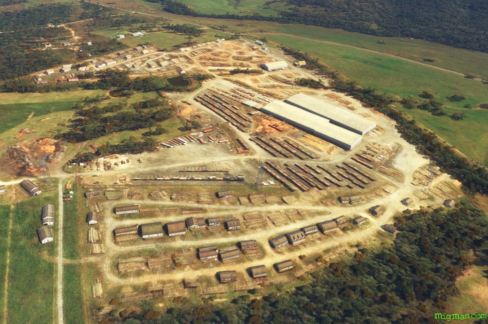
Glenreagh, Timber Town
AboutVisit one of Australia's oldest 'timber towns', Glenreagh in the Clarence Valley, population 900.
Return to Coffs Harbour via the coast, passing from Wooli: Freshwater, Corindi, Safety, Sandy, Emerald and Sapphire beaches.
Return to Coffs Harbour via the coast, passing from Wooli: Freshwater, Corindi, Safety, Sandy, Emerald and Sapphire beaches.
Australia
location_cityN.S.W. | North Coast
flight_takeoffYCFS Coffs Harbour
airline_seat_recline_extraAustralia 1
tagBridges
tagCoastal flight
tagDam spotting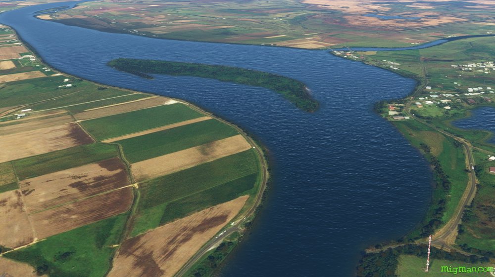
Grafton Coast and the Clarence River
AboutThe Jacaranda capital of Australia, Grafton lays astride the Clarence river and features Edwardian and Victorian architecture.
Fly east of Grafton to the coast and then north to the coastal towns of Wooli, Minnie Water, Sandon, Brooms Head, Angourie Point and Yamba. Then return to Grafton via the Clarence River.
Fly east of Grafton to the coast and then north to the coastal towns of Wooli, Minnie Water, Sandon, Brooms Head, Angourie Point and Yamba. Then return to Grafton via the Clarence River.
Australia
location_cityN.S.W. | North Coast
flight_takeoffYGFN Grafton
airline_seat_recline_extraAustralia 2
tagCoastal flight
tagBridges
Grafton's Gorgeous Rivers
AboutGrafton sits on a large plain and your first waypoint, Shannon Creek Dam, is just inside the mountains at the western edge of that plain. Explore the Mann and Clarence Rivers to the north-west of Grafton.
Copmanhurst, population 300, is a popular camping and kayaking spot on the Clarence River.
Copmanhurst, population 300, is a popular camping and kayaking spot on the Clarence River.
Australia
location_cityN.S.W. | North Coast
flight_takeoffYGFN Grafton
airline_seat_recline_extraAustralia 2
tagBridges
tagDam spotting
Evans Head Air Weapons Range
AboutTake a few passes at the Air Weapons Range just 12 miles south of picturesque Evans Head.
Australia
location_cityN.S.W. | North Coast
flight_takeoffYEVD Evans Head
airline_seat_recline_extraAustralia 2
tagBridges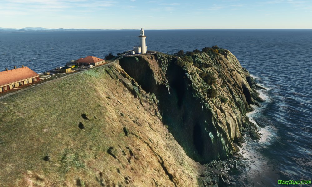
Ballina to Byron via Twin Towns
AboutByron Bay was traditionally a sanctuary for 'Age of Aquarians', which peaked in the 1960s. Nowadays it remains a popular tourist resort and hosts an annual blues festival which looks back longingly to Woodstock and Australia's own Sunbury. Tweed Head (NSW) and Coolangatta (QLD) sit astride the N.S.W./Queensland border and are known as the "Twin Towns".
Australia
location_cityN.S.W. | North Coast
flight_takeoffYBNA Ballina
airline_seat_recline_extraAustralia 2
tagBorder Patrol
tagCoastal flight
tagDam spotting
Mount Warning, but 'Bob's your uncle'
AboutLismore is one of the largest regional centres in northern N.S.W. and is a locus for the boomer era counter-culture, much like Ballina, Byron Bay and Nimbin. Mount Warning is a volcanic plug, with about half the crater walls remaining and forming a very distinctive landmark. It last erupted about 23 million years back so 'Bob's your uncle' as we say down under. **
But you never know!
** Translation: Conditions are optimal. Luck not required.
But you never know!
** Translation: Conditions are optimal. Luck not required.
Australia
location_cityN.S.W. | North Coast
flight_takeoffYLIS Lismore
airline_seat_recline_extraAustralia 2
tagBridges
tagCoastal flight
tagDam spotting
Beef Capital of Australia
AboutLismore is one of the largest regional centres in northern N.S.W. and is a locus for the boomer era counter-culture movements, much like Ballina, Byron Bay and Nimbin.
Casino is the 'Beef Capital of Australia' and has a population around the 12,000 mark. 12,000 people that is, the cattle population is much higher. It was originally named 'Cassino' after Monte Cassino in Italy, but a bureaucratic error led to the current spelling becoming official. C'est la vie.
Casino is the 'Beef Capital of Australia' and has a population around the 12,000 mark. 12,000 people that is, the cattle population is much higher. It was originally named 'Cassino' after Monte Cassino in Italy, but a bureaucratic error led to the current spelling becoming official. C'est la vie.
Australia
location_cityN.S.W. | North Coast
flight_takeoffYLIS Lismore
airline_seat_recline_extraAustralia 2
tagDam spotting
Birthplace of Australia
AboutTenterfield is where, in 1889, Sir Henry Parkes made a famous speech calling for Australia's federation, which became a reality in 1901. Today Tenterfield is in beef country and famous for it's fine wineries.
Rangers Valley was established in on the lush New England Tablelands 1839 by Oswald Bloxsome who had arrived in Sydney from the United Kingdom ten years before. Today it runs 40,000 cattle on the 12,000 acre property under the ownership of Marubeni and supplies grain fed Wagyu beef to the Japanese market.
Glenyon Dam, which feeds into Pike Creek and thence the New England Tablelands, is just across the border in Queensland and covers a massive 1,295 km2.
Australia
location_cityN.S.W. | New England North West
flight_takeoffYGLI Glen Innes
airline_seat_recline_extraAustralia 2
tagBorder Patrol
tagDam spotting
tagCanyon runs & Mach Loops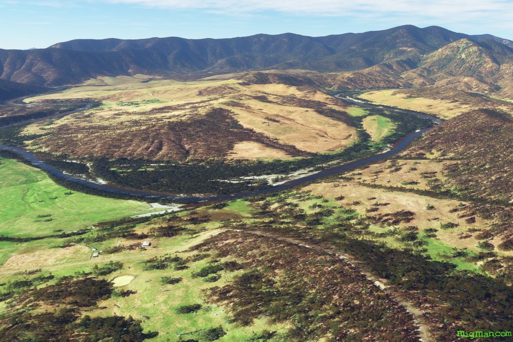
Mann and Boyd River Valleys
AboutCheck out a few of the spectacular valleys in the Great Dividing Range, to the east of the Northern Tablelands.
The Mann River and Boyd Rivers run all year and are part of the Clarence River catchment.
The Mann River and Boyd Rivers run all year and are part of the Clarence River catchment.
Australia
location_cityN.S.W. | New England North West
flight_takeoffYGLI Glen Innes
airline_seat_recline_extraAustralia 2
tagCanyon runs & Mach Loops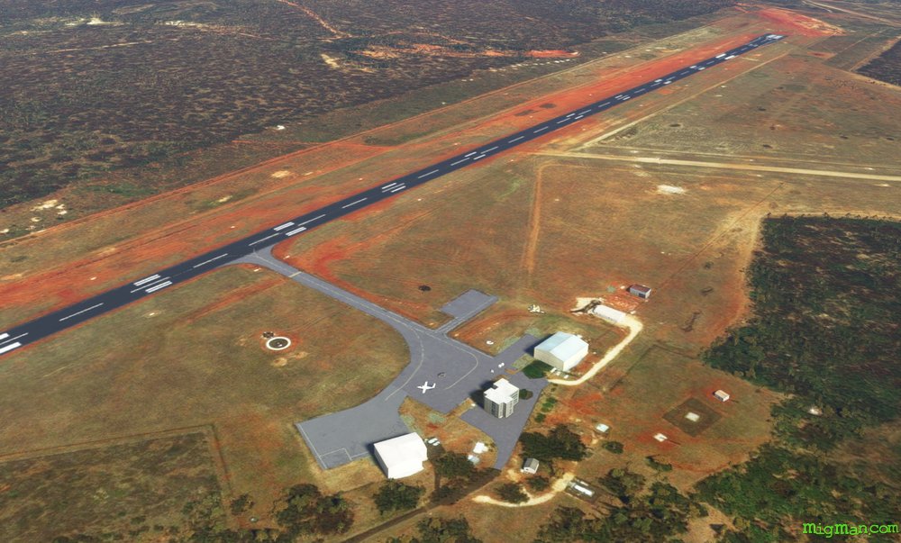
Inverell, Sapphire City
AboutSitting astride the Macintyre River, Inverell has been a source of diamonds and sapphires from the mid 19v onwards.
Nowadays the main activities are tourism and a variety of crop cultivation.
Nowadays the main activities are tourism and a variety of crop cultivation.
Australia
location_cityN.S.W. | New England North West
flight_takeoffYIVL Inverell
airline_seat_recline_extraAustralia 2
tagCanyon runs & Mach Loops
tagAiports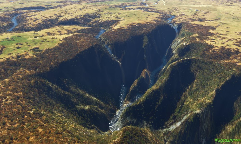
Oxley Wild River Gorges
AboutExplore the Oxley Wild Rivers National Park to the east of Armidale. Armidale is the Northern Tablelands administrative centre, about halfway between Sydney and Brisbane and also home to the University of New England.
Oxley Wild Rivers National Park covers 1,452 km2 of extremely rugged rainforest covered terrain. Get your first glimpse of the spectacular gorges at the town of Hillgrove, and then Wollomombi Falla and Oakey River Dam. These three spots are all on the northern end of valley which are just begging to be explored by you!
Waypoints 4,5 and 6 take you down the eastern border of this area, west across the bottom and back up the western border to WP 6. I suggest you explore the wider valleys heading south and then climb to about 7,000 ft at WP 4 and enjoy the view from above. But, the world is your oyster so just go for it! Of course at anytime you can curtail your exploration and head back to Armidale.
Australia
location_cityN.S.W. | New England North West
flight_takeoffYARM Armidale
airline_seat_recline_extraAustralia 2
tagBorder Patrol
tagDam spotting
tagCanyon runs & Mach Loops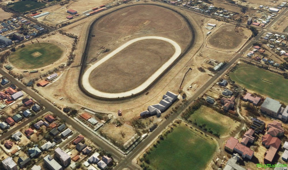
A Day at the Races
AboutMost large country towns feature a racecourse and a golf course, both of which help you build a mental map where the airport is located.
Armidale Racecourse is about 2 miles NE of the airport. See if you can spot the golf course?
About 10 nm NE of Armidale airport is Woodville Airport YWVI, whose grass runways can be quite hard to spot from a distance. By pure luck your flight path follows a dirt road which leads directly to it.
Armidale Racecourse is about 2 miles NE of the airport. See if you can spot the golf course?
About 10 nm NE of Armidale airport is Woodville Airport YWVI, whose grass runways can be quite hard to spot from a distance. By pure luck your flight path follows a dirt road which leads directly to it.
Australia
location_cityN.S.W. | New England North West
flight_takeoffYARM Armidale
airline_seat_recline_extraAustralia 2
tagAiports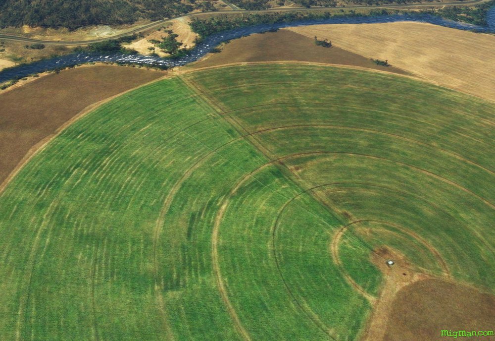
Tamworth’s Valleys
AboutEnjoy the of lush river valleys to the south east of Australia's Capital of Country Music: Tamworth.
Tamworth YSTW is one of the few airports in the New England region with a control tower amd two parallel runways.
Entire route: 77 nm
Shorter return flights: 5 nm to WP 1, 200 yds S of Australia's largest guitar: 'The Big Golden Guitar'.'The Big Golden Guitar', which is currently down for maintenance. But watch that space!
6 nm to WP 5 Flagstaff Mountain
40 nm to Woolomin Airport YWOM, about 1.6 nm N of Chaffey Dam at WP 3
Tamworth YSTW is one of the few airports in the New England region with a control tower amd two parallel runways.
Entire route: 77 nm
6 nm to WP 5 Flagstaff Mountain
40 nm to Woolomin Airport YWOM, about 1.6 nm N of Chaffey Dam at WP 3
Australia
location_cityN.S.W. | New England North West
flight_takeoffYSTW Tamworth
airline_seat_recline_extraAustralia 2
tagDam spotting
tagCanyon runs & Mach Loops
Quirindi, Wallabadah & Currububula
AboutSay that four times quickly!
With a population of around 3,000, Quirindi is typical of many small country towns in Australia. Like many place names in Australia, Quirindi is a word from one of the 400 plus Aboriginal languages. It's meaning is not agreed upon.
Wallabadah, population ~ 300 is named after an Aboriginal word meaning 'stone'. Wallabadah Airport appears to be a grass strip NE of town.
Currabubula, population ~ 300, named after a word from the Kamilaroi language.
Australia
location_cityN.S.W. | New England North West
flight_takeoffYQDI Quirindi
airline_seat_recline_extraAustralia 2
tagDam spotting
Cotton Pickin' Moree
AboutMoree is known for it's cotton farms and the natural spas which have been sourced from the hot springs of the Great Artesian Basin since 1895.
Australia
location_cityN.S.W. | New England North West
flight_takeoffYMOR Moree
airline_seat_recline_extraAustralia 2
Narrabri's Massive Mines
AboutWhitehaven runs about 11 coal mining operations in the region. On this flight check out the Whitehaven, Boggabri and Maules Creek locations.
Australia
location_cityN.S.W. | New England North West
flight_takeoffYNBR Narrabri
airline_seat_recline_extraAustralia 2
tagCanyon runs & Mach Loops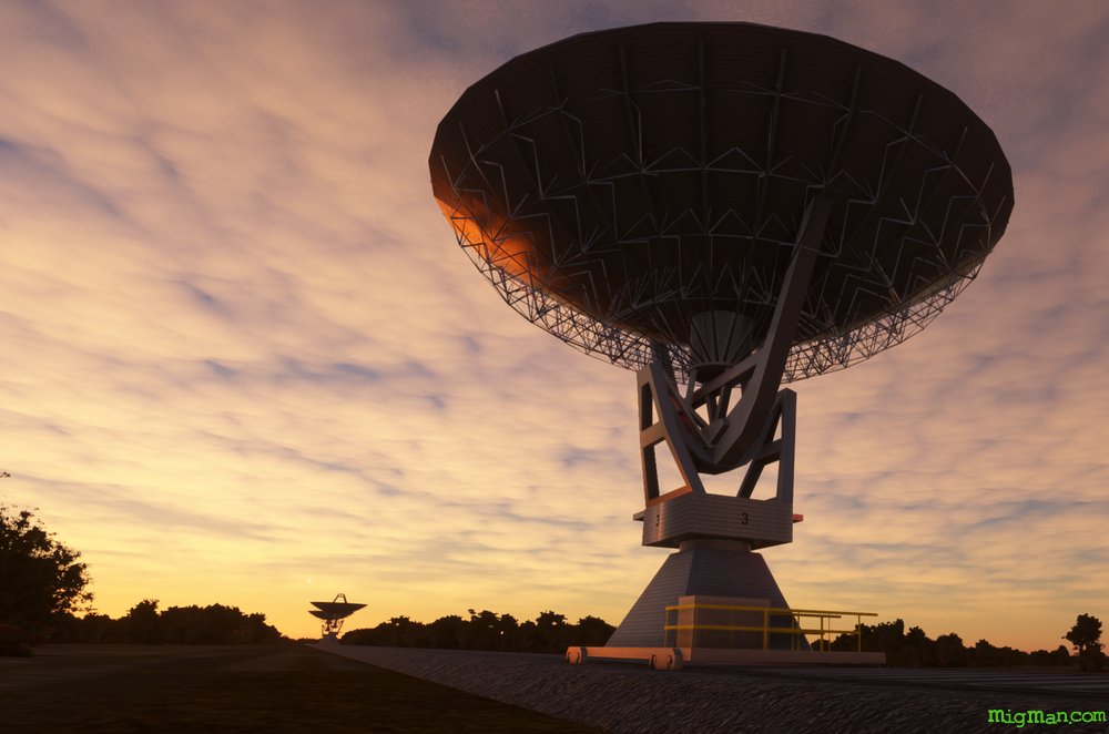
CSIRO Paul Wild Observatory
AboutCSIRO is an acronym every Australian school-child knows: Commwealth Scientific Industrial Research Organisation, which discovered wi-fi amongst many other useful things.
The CSIRO Paul Wild Observatory is home of the Australia Telescope Compact Array and the Culgoora Solar Observatory.
Entire route: 47 nm
Shorter return flights: ESE for 8 nm to CSIRO Paul Wild Observatory at WP 1
NE for 10 nm to the Australian Cotton Researchg Institute at WP 4
The CSIRO Paul Wild Observatory is home of the Australia Telescope Compact Array and the Culgoora Solar Observatory.
Entire route: 47 nm
Shorter return flights: ESE for 8 nm to CSIRO Paul Wild Observatory at WP 1
NE for 10 nm to the Australian Cotton Researchg Institute at WP 4
Australia
location_cityN.S.W. | New England North West
flight_takeoffYWWA Wee Wah
airline_seat_recline_extraAustralia 2
tagAiports
Gunnedah & Lake Keepit
About
Explore the beautiful Lake Keepit, some 13nm NE of Gunnedah.
Australia
location_cityN.S.W. | New England North West
flight_takeoffYGDH Gunnedah
airline_seat_recline_extraAustralia 2
tagDam spotting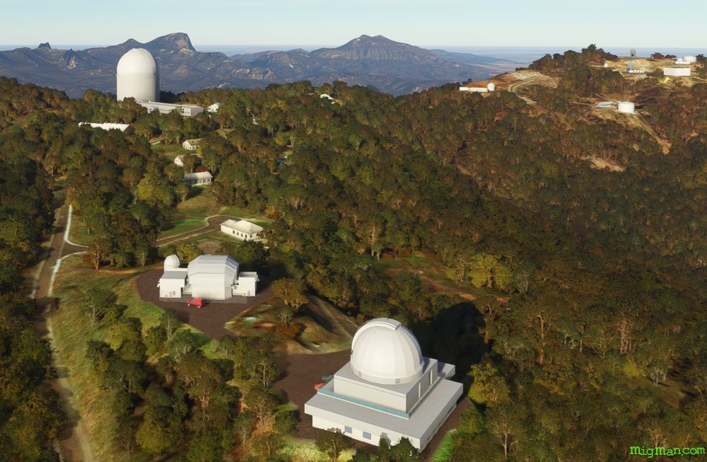
Coonabarabran & the Warrumbungles
AboutVisit the Siding Spring Observatory complex set in the rugged Warrumbungle Mountains near Coonabarabran.
Shorter flights: 3 nm to Coonabarabran at WP 1. 11 nm direct to Siding Spring Observatory at WP 3
Shorter flights: 3 nm to Coonabarabran at WP 1. 11 nm direct to Siding Spring Observatory at WP 3
Australia
location_cityN.S.W. | Central West & Orana
flight_takeoffYCBB Coonabarabran
airline_seat_recline_extraAustralia 2
tagDam spotting
Gilgandra, the Long Water Hole
AboutTowards the western edge of New England region we get a taste of the vast plains which form much of Australia's interior.
Gilgandra means 'long water hole' in Aboriginal, as it sits on the meandering banks of the Castlereagh River.
Gilgandra means 'long water hole' in Aboriginal, as it sits on the meandering banks of the Castlereagh River.
Australia
location_cityN.S.W. | Central West & Orana
flight_takeoffYGIL Gilgandra
airline_seat_recline_extraAustralia 2
tagBridges
tagAiports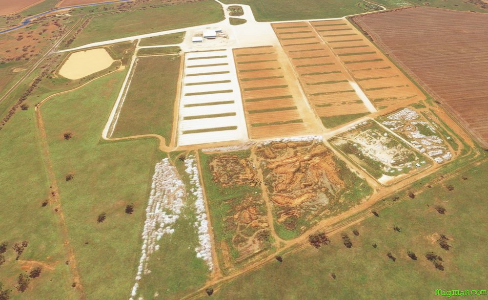
Dubbo and the Cotton Gins
AboutDubbo is Aussie slang for a person who is 'a little slow on the uptake'. Dubbo is also one of our largest regional centres, with the 300 hectare Western Plains Zoo being a major tourist attraction.
Cotton gins separate the cotton from the seed, a process which prior to the industrial revolution was done by hand.
Cotton gins separate the cotton from the seed, a process which prior to the industrial revolution was done by hand.
Australia
location_cityN.S.W. | Central West & Orana
flight_takeoffYSDU Dubbo
airline_seat_recline_extraAustralia 2
tagAiports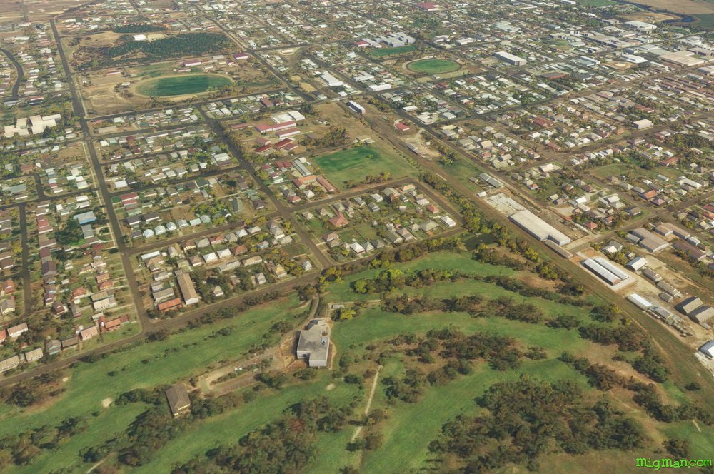
Mudgee, Nest in the Hills
AboutMudgee is a favourite 'get-away' spot for Sydney-siders, being about a 3 1/2 hour drive and boasting many wineries and restaurants. Mudgee means 'nest in the hills' in Aboriginal.
Australia's transition to decimal currency happened in 1966 and Gulgong, birthplace of poet Henry Lawson, was featured on the $10 note. Gulgong is also home to Prince of Wales Opera House, Australia's first, built in 1871. Gulgong means 'deep waterhole' in Aboriginal.
Australia's transition to decimal currency happened in 1966 and Gulgong, birthplace of poet Henry Lawson, was featured on the $10 note. Gulgong is also home to Prince of Wales Opera House, Australia's first, built in 1871. Gulgong means 'deep waterhole' in Aboriginal.
Australia
location_cityN.S.W. | Central West & Orana
flight_takeoffYMDG Mudgee
airline_seat_recline_extraAustralia 2
tagBridges
tagDam spotting
tagCanyon runs & Mach Loops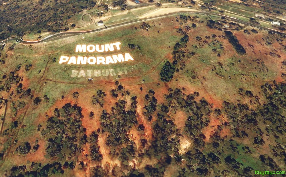
Bathurst Gladiators
AboutThe Bathurst races have been a fixture of Australian culture for as long as I can remember. They fuelled the aspirations of many an Aussie teenager as they saved their pennies to get 'into the race' with their own version of an Aussie Supercar.
Traditionally the battle was between Holden and Ford. The current incarnation of this gladiatorial contest is a 1,000-kilometre race on the gruelliung Mount Panorama Circuit.
Bathurst is the oldest inland settlement in Australia. Ben Chifley, born in Bathurst, was a train driver who became Prime Minister of Australia from 1945 to 1949.
Australia
location_cityN.S.W. | Central West & Orana
flight_takeoffYBTH Bathurst
airline_seat_recline_extraAustralia 2
tagDam spotting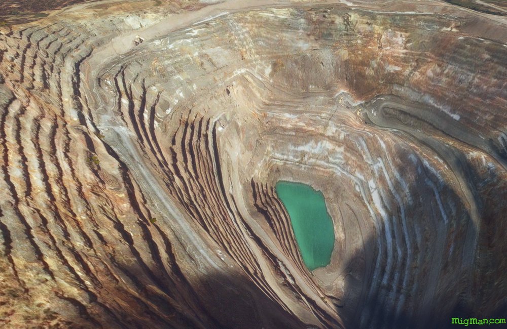
There's gold in them thar hills!'
AboutAt Orange you'll find not just gold, but also molybdenum and copper being extracted at the Cadia Hill facility, which is a far cry from the hand-panning methods used in the first gold rush of 1851.
Australia
location_cityN.S.W. | Central West & Orana
flight_takeoffYORG Orange
airline_seat_recline_extraAustralia 2
tagDam spotting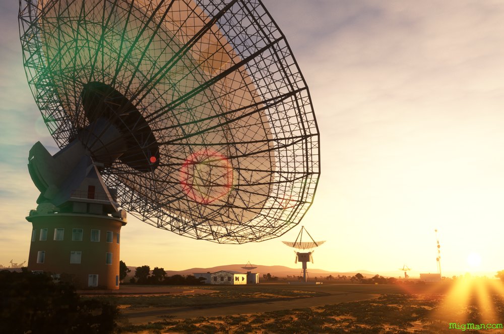
Per Ardua ad Astra
AboutParkes Radio Telescope has been operating continuously for more than 50 years and represents a 20th century confluence of mathematics, engineering and astronomy..
It is part of the CSIRO Parkes Observatory and in 2016 found the only discovered binary system of two pulsars.
It is part of the CSIRO Parkes Observatory and in 2016 found the only discovered binary system of two pulsars.
Australia
location_cityN.S.W. | Central West & Orana
flight_takeoffYPKS Parkes
airline_seat_recline_extraAustralia 2
tagDam spotting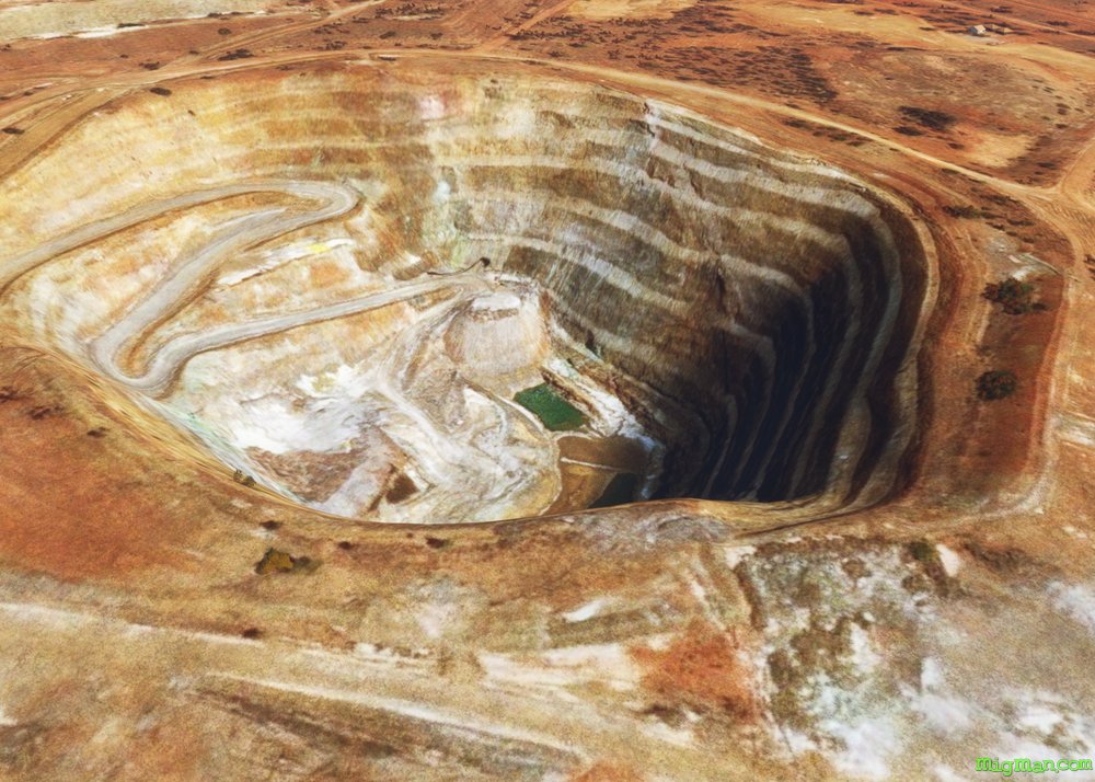
Carpe Cuprum
AboutLatin: Sieze the copper! This region of NSW has enormous reserves of copper.
Copper has been serving mankind for about 11,000 years in weaponry and cookware. Since the work of Franklin and Faraday in the 19c it has been the circulatory system of the modern world, conducting electricity across continents into our homes, and around our electronic devices.
Copper has been serving mankind for about 11,000 years in weaponry and cookware. Since the work of Franklin and Faraday in the 19c it has been the circulatory system of the modern world, conducting electricity across continents into our homes, and around our electronic devices.
Australia
location_cityN.S.W. | Central West & Orana
flight_takeoffYNYN Nyngan
airline_seat_recline_extraAustralia 2
Mighty Murray & Murrumbidgee
AboutFly past the two longest rivers on the mighty Australian continent. The Murray defines most of the border between NSW and Victoria and runs to 1,558 miles with the Murrumbidgee coming in a close second at 923 miles. OK, not that close perhaps, but definetely getting a silver in the river Olympics!
Australia
location_cityN.S.W. | Far West
flight_takeoffYBRN Balranald
airline_seat_recline_extraAustralia 3
tagBorder Patrol
tagBridges
tagCanyon runs & Mach Loops
Back o’ Bourke
AboutBack o’Bourke: is an expression allegedly minted by poet Henry Lawson, and refers to Bourke's place at the edge of civilisation. Bourke is at the western edge of the agricultural regions of New South Wales and is a gateway to the vast and arid Australian outback. Take a short trip around the local farms and marvel at the vast, dry red plains beyond.
Australia
location_cityN.S.W. | Far West
flight_takeoffYBKE Bourke
airline_seat_recline_extraAustralia 3
tagDam spotting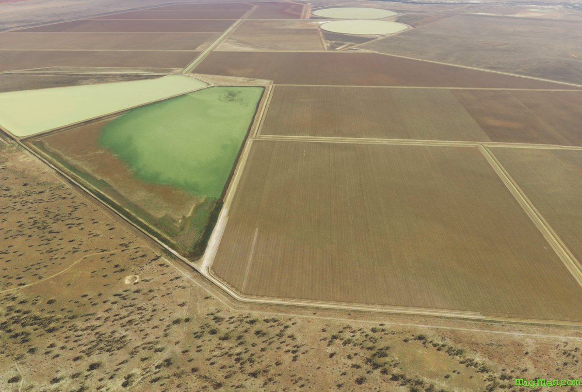
Wild Gooseberries and River Boats
AboutBrewarrina is an aboriginal term for the native gooseberry. In the 1860s Brewarrina was a busy port for shipping wool to Adelaide (captial of South Australia). It's quite the feat of imagination these days to picture river boats making the long journey along the meandering path of the Darling River!
Australia
location_cityN.S.W. | Far West
flight_takeoffYBRW Brewarrina
airline_seat_recline_extraAustralia 3
tagAiports
Mad Max, the Road Warrior
AboutBroken Hill, as far west as you can get in NSW, is famous for two things: the BHP mining company and Mad Max 2, the greatest road movie ever made. Director George Miller cast a young Mel Gibson as the eponymous road warrier in iconic the post-apocalyptic Mad Max trilogy. Generations of Aussies grew up driving too fast as a result. But all in good fun. One of the household names in Australian industry is Broken Hill Proprietary (BHP). It began mining in 1885 with silver, lead and zinc mines in Broken Hill and evolved into a major force in iron ore, copper, oil and gas, diamonds, silver, lead, zinc and steel manufacture.
Australia
location_cityN.S.W. | Far West
flight_takeoffYBHI Broken Hill
airline_seat_recline_extraAustralia 3
tagBorder Patrol
tagDam spotting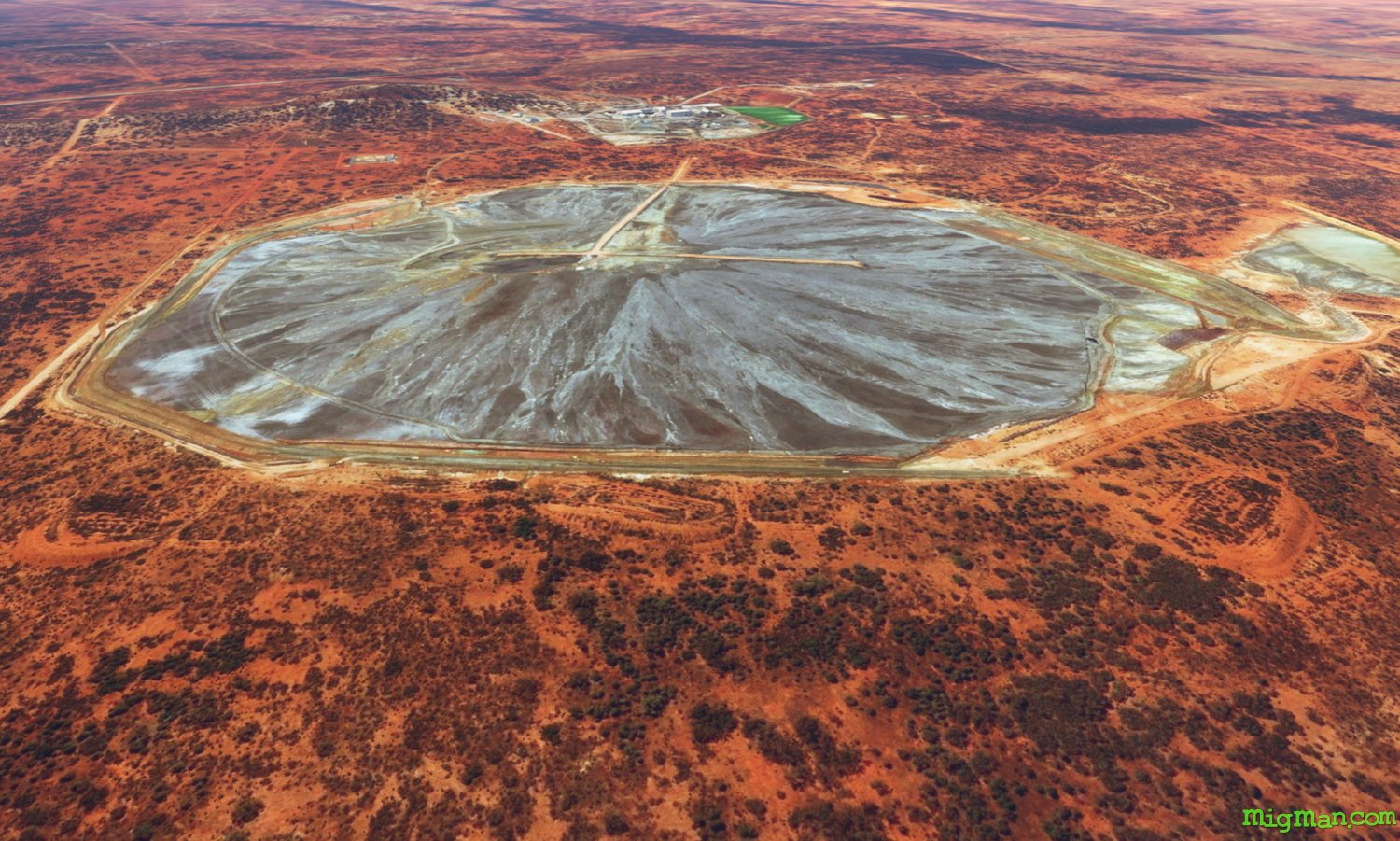
Cobar Gold Diggers
AboutLocated in the far NW of N.S.W. at the intersection of Kidman Way and the Barrier Highway, Cobar's main activity is mining. One of the oldest, Peak Gold Mine was opened in 1896, and the CSA Mine is one of Australia's highest grade copper mines.
Australia
location_cityN.S.W. | Far West
flight_takeoffYCBA Cobar
airline_seat_recline_extraAustralia 3
Water and Cotton
AboutExplore the vast irrigation bores, reservoirs and ditches around Collarenebri, and fly over Moomin Gin. In 1962 a small group of pioneering cotton growers formed a cooperative at Wee Waa and processed 98 bales of cotton in the first year. Today Namoi Cotton processes up to 84,000 bales per week at it's 11 facilities. In 1794 the first cotton gin patent was granted in the USA to Eli Whitney. Today at Moomin Cotton Gin the process of separating cotton lint from it's seeds with the descendants of Whitney's invention.
Australia
location_cityN.S.W. | Far West
flight_takeoffYCBR Collarenebri
airline_seat_recline_extraAustralia 3
tagBridges
tagAiports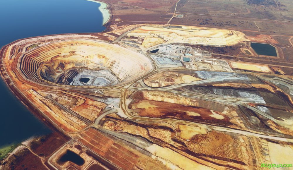
The Centre of NSW
AboutCondobolin is 4 miles south of Mount Tilga (329 feet), which is regarded as the geographical centre of New South Wales. Visit Lake Cowal Gold Mine which presents a stunning warm palette next to the cool waters of Lake Cowal.
Australia
location_cityN.S.W. | Central West & Orana
flight_takeoffYCDO Condobolin
airline_seat_recline_extraAustralia 3
tagBridges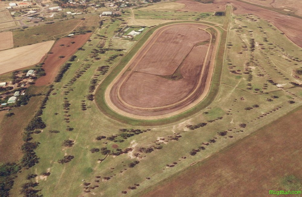
Pilliga State Forest
AboutTraverse the western area of the vastness that is Pilliga State Forest.
Australia
location_cityN.S.W. | Central West & Orana
flight_takeoffYCNM Coonamble
airline_seat_recline_extraAustralia 3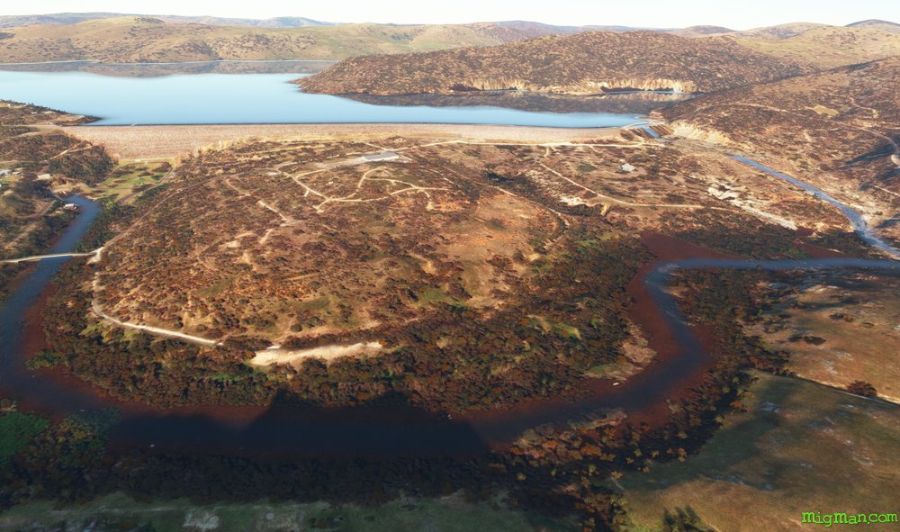
Lake Wyangala
AboutVisit Lake Wyangala Dam (built in 1935) and return via Charcoar Dam and the Mid Western Highway. Or, if you prefer, follow the rail line. Note: We also visit Carcoar Dam in the flight out of Orange.
Australia
location_cityN.S.W. | Central West & Orana
flight_takeoffYCWR Cowra
airline_seat_recline_extraAustralia 3
tagDam spotting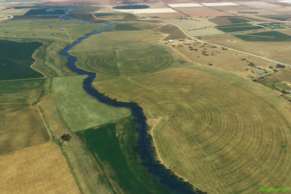
Escape from Cowra
AboutIn 1944 more than 1,000 Japanese POWs broke out of Cowra Prisoner of War camp, the site of the largest POW breakout in Australian and British history. 231 Japanese died in the incident and 4 Australians. Today Cowra is known for it's vineyards, livestock and vegetables. The POW camp site is preserved with a few structures and the visitor information centre has a scale model and audio visual presentations.
Australia
location_cityN.S.W. | Central West & Orana
flight_takeoffYCWR Cowra
airline_seat_recline_extraAustralia 3
tagDam spotting
tagCanyon runs & Mach Loops
tagAiports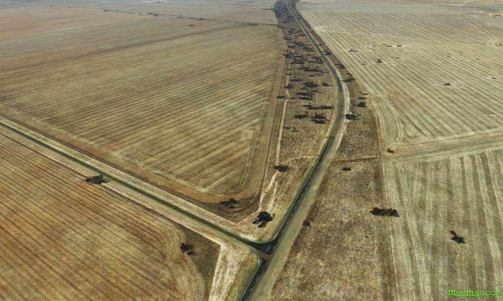
Clancy of the Overflow
AboutNamed after Governor Lachlan Macquarie, the fifth governor of NSW (1810 to 1821) the Lachlan River runs east to west through Forbes. Australian schoolchildren know it from the iconic Aussie poem "Clancy of the Overflow" by Banjo Paterson.
NOTAM: The plains around the Lachlan River are so flat that hills of 500 feet stand out starkly and are useful aids to navigation. Where there is no terrain relief at all, look for junctions of straight lines such as road and rail intersections.
NOTAM: The plains around the Lachlan River are so flat that hills of 500 feet stand out starkly and are useful aids to navigation. Where there is no terrain relief at all, look for junctions of straight lines such as road and rail intersections.
Australia
location_cityN.S.W. | Central West & Orana
flight_takeoffYFBS Forbes
airline_seat_recline_extraAustralia 3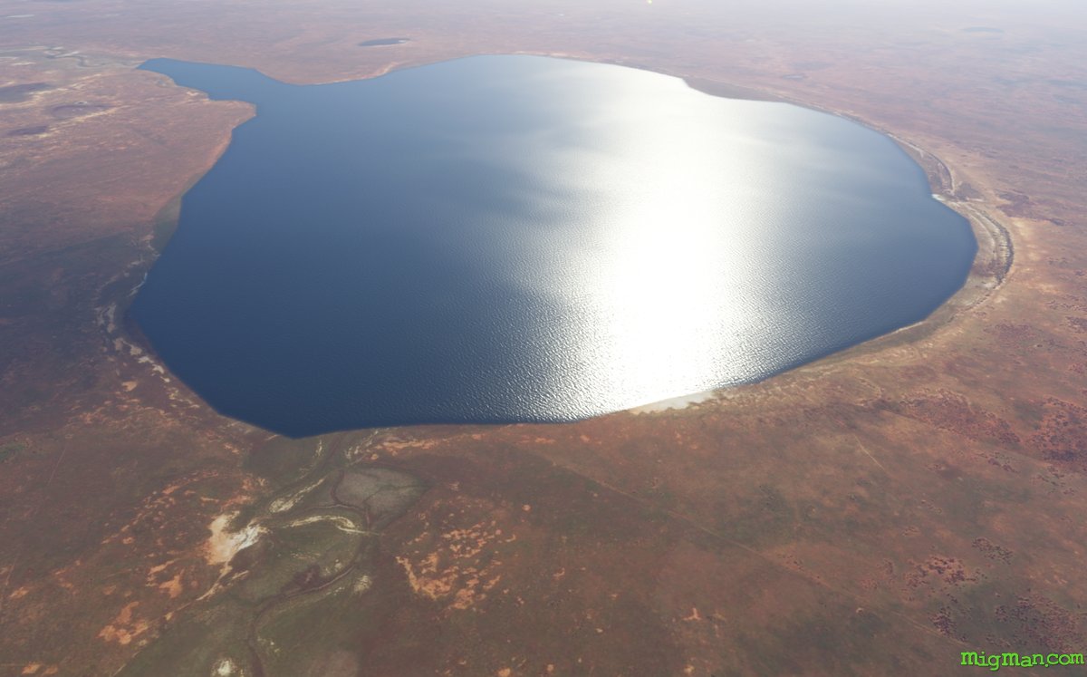
Lady of the Lake
AboutFind the fabled Lady of the Lake, but which lake? Ivanhoe was named after Sir Walter Raleigh's eponymous work in the 1870's. Why it was founded at that exact spot is a mystery as the nearest potable water was some 25 km away at Kilfera Lake. The literature-loving founder of Ivanhoe, George Williamson, quested on to Camelot in 1907.
Australia
location_cityN.S.W. | Far West
flight_takeoffYIVO Ivanhoe
airline_seat_recline_extraAustralia 3
tagAiports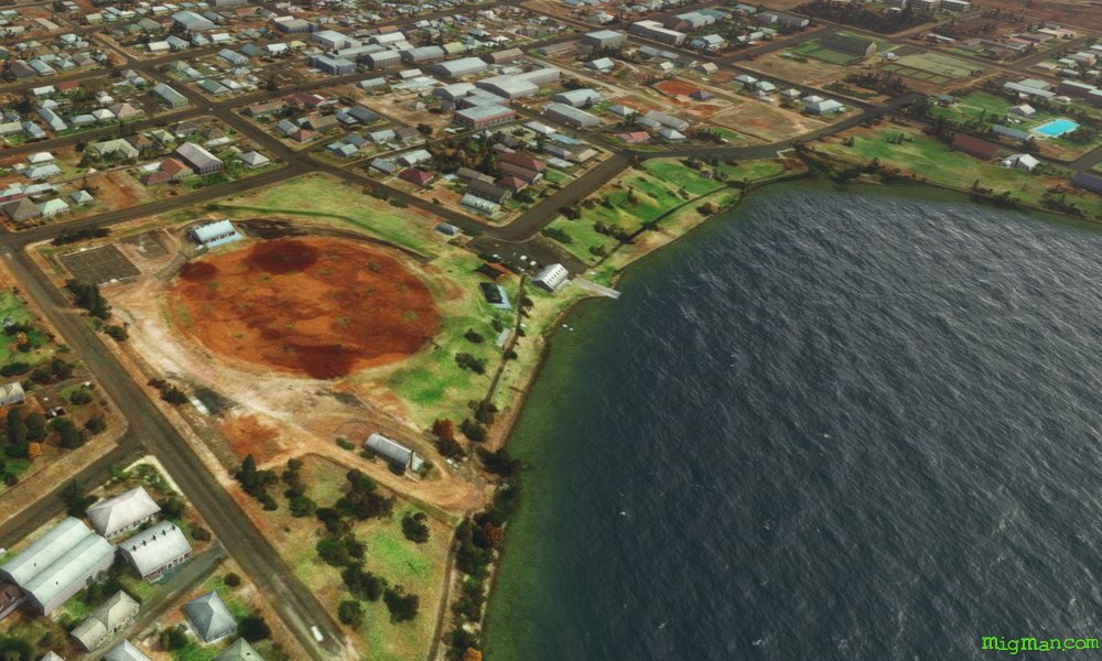
The Songs of Lake Cargelligo
AboutThe combination of wheat and fruit growing in the aread attracts a variety of birds which congregate around the lake. If you sit quietly by the lake you can hear them sing! Lake Cargelligo was first surveyed in 1817 by John Oxley, but didn't attract an appreciable population until gold was discovered by a cook in 1873.
Australia
location_cityN.S.W. | Central West & Orana
flight_takeoffYLCG Lake Cargelligo
airline_seat_recline_extraAustralia 3
tagCanyon runs & Mach Loops
Mineral Sands
AboutThe Snapper and Ginkgo mines extract Rutile (Titanium Dioxide TiO2), Zircon (Zirconium Silicate ZrSiO4) and Ilmenite (Titanium Iron Oxide FeTiO3), which is a key component of products ranging from paints and inks to fabrics, plastics, paper and cosmetics.
Australia
location_cityN.S.W. | Far West
flight_takeoffYLMU Mungo Lodge Airport
airline_seat_recline_extraAustralia 3
tagAiports
Black Opal
AboutLightning Ridge, known for it's Black Opals, is near the border of NSW and Queensland in NSW Far West.
Australia
location_cityN.S.W. | Far West
flight_takeoffYLRD Lightning Ridge
airline_seat_recline_extraAustralia 3
tagBorder Patrol
tagBridges
tagAiports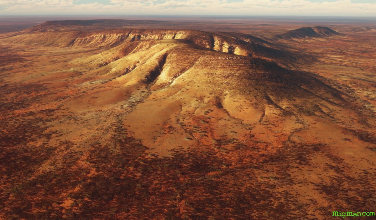
Inland Sea
AboutUntil 65 million years ago Australia was 1/4 covered by a vast inland sea. At Louth we get our first sightings of the rolling and worn mountain ranges which permeate the largely flat former seabed.
Australia
location_cityN.S.W. | Far West
flight_takeoffYLOH Louth
airline_seat_recline_extraAustralia 3
Pearls in the Desert, Airport on a Lake
AboutThe water management scheme at Menindee Lakes was started in 1949 and acts as a storage area for tje outflow of nine major river systems. Lake Tandou, at the south west end, is protected from flooding, used to grow a variety of crops and has it's own airport. The main lakes, from north east to south west are: Lake Malta, Lake Wetherell, Lake Balaka, Lake Bijijie, Lake Tandure, Lake Pamamaroo, Lake Speculation, Lake Menindee (the largest lake), Emu Lake, Lake Cawndilla, Kangaroo Lake and Lake Pamamaroo.
NOTAM. As of June 2023 MSFS shows Tandou Lake YTAD as being out of service. Menindee YMED is also out of service.
NOTAM. As of June 2023 MSFS shows Tandou Lake YTAD as being out of service. Menindee YMED is also out of service.
Australia
location_cityN.S.W. | Far West
flight_takeoffYBHI Broken Hill
airline_seat_recline_extraAustralia 3
tagAiports
Tri-State Border
AboutFly to Cameron corner where where New South Wales, Queensland & South Australia meet.
Try flying at higher altitudes such as 5,000 feet to truly appreciate the artistic patterns created here by the interaction of desert and water.
Australia
location_cityN.S.W. | Far West
flight_takeoffYTIB Tibooburra
airline_seat_recline_extraAustralia 3
tagBorder Patrol
tagDam spotting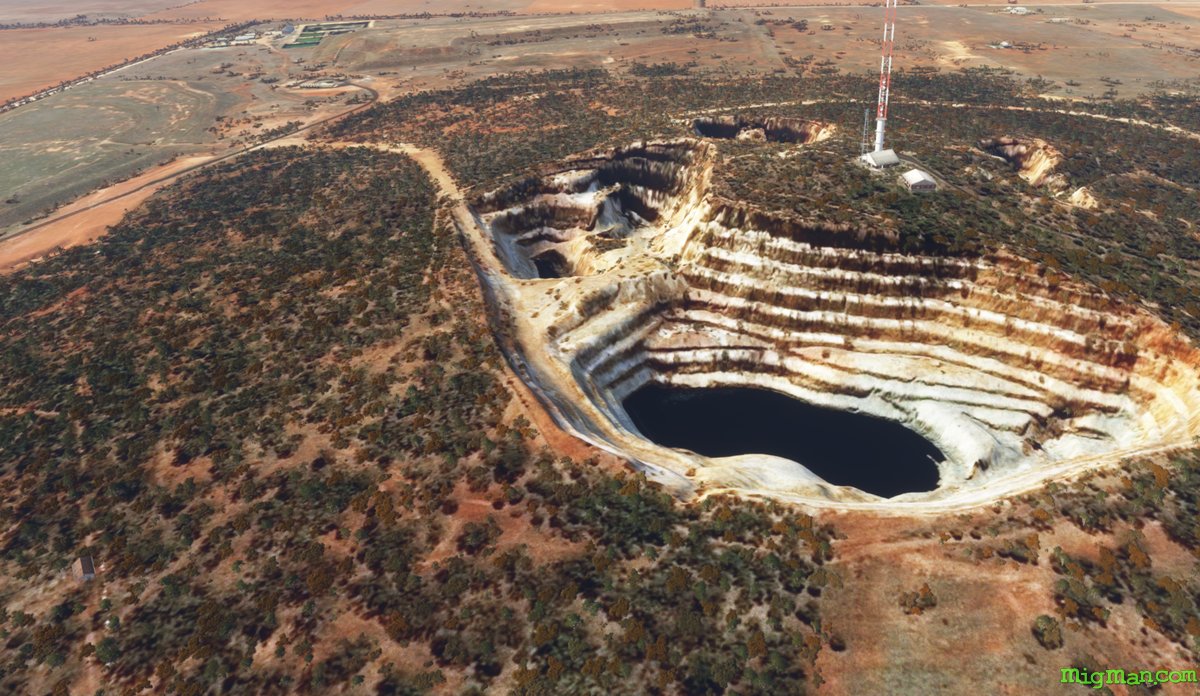
Fly The Bogan Way
AboutBogan' is Australian patois for 'a very simple person', Forrest Gump springs to mind. Bogan also refers to a very large moth which descends randomly upon Sydney in plague proportions and is regarded as a delicacy by connoiseurs of Bush Tucker.
Australia
location_cityN.S.W. | Central West & Orana
flight_takeoffYTOT Tottenham
airline_seat_recline_extraAustralia 3
tagAiports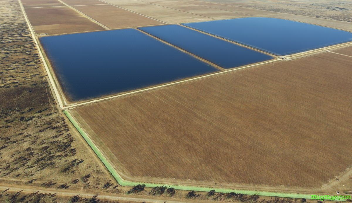
Meeting of Two Waters
AboutWalgett is an Aboriginal word meaning "meeting of two waters", in this case the Namoi and Barwon Rivers. The area is an agricultural powerhouse, producing everything from Murray Cod (fish) to mutton and wool, beef, chick peas, barley, lucerne, cotton and wheat.
Australia
location_cityN.S.W. | Far West
flight_takeoffYWLG Walgett
airline_seat_recline_extraAustralia 3
tagBridges
tagAiports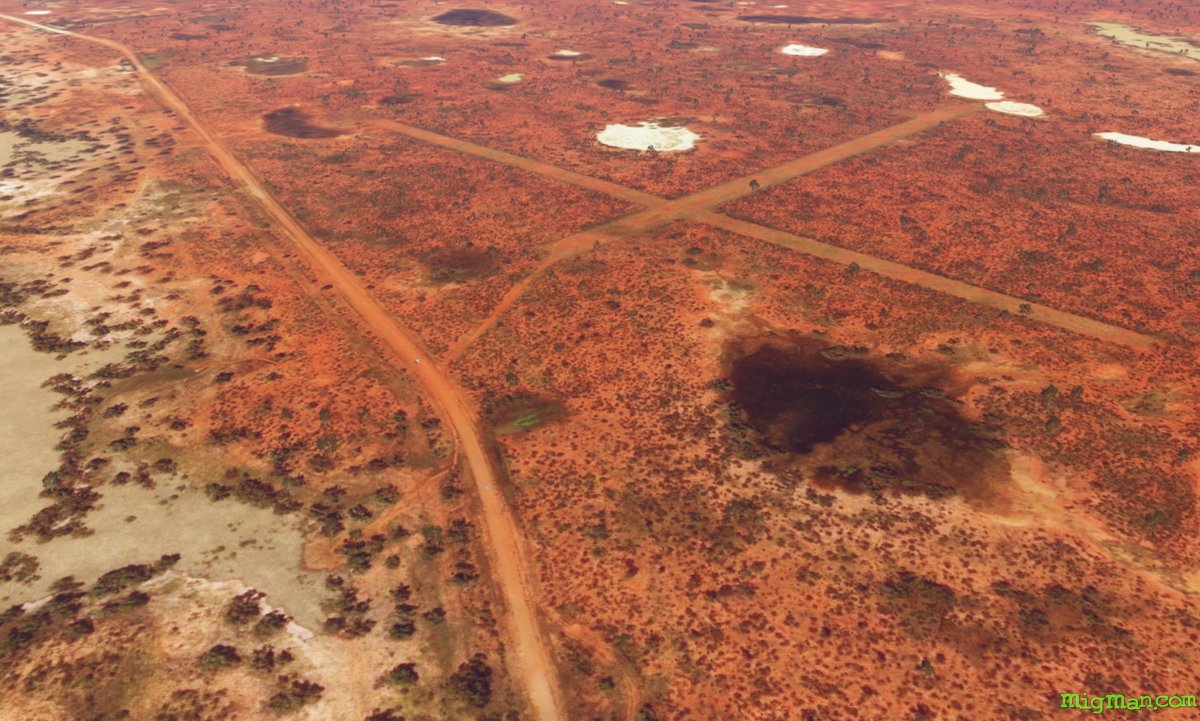
Bush Strips Back'o'Burke
AboutGet a taste of outback aviating by performing touch'n'goes at these remote airstrips. Most of these service the cattle stations which typically run to thousands of acres on the parched red earth found through most of the Australian outback.
Australia
location_cityN.S.W. | Far West
flight_takeoffYWAG Wanaaring
airline_seat_recline_extraAustralia 3
tagAiports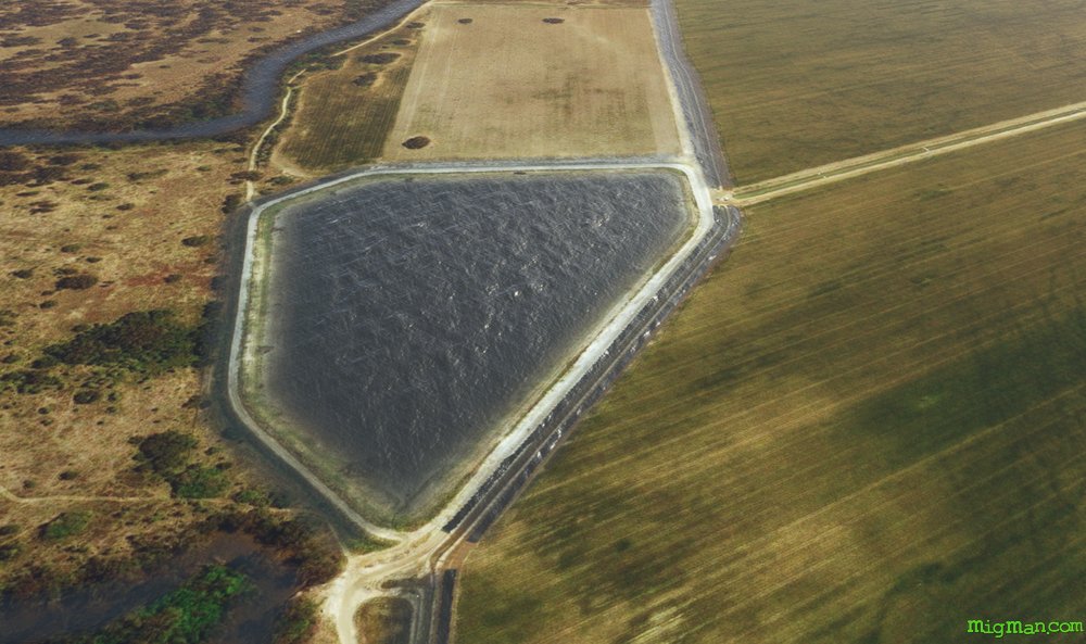
Warren's Wool
AboutEnjoy the colours of the lush irrigated farms along the Macquarie River north of Warren. The main products of the region are cotton and fine Merino wool.
Australia
location_cityN.S.W. | Central West & Orana
flight_takeoffYWRN Warren
airline_seat_recline_extraAustralia 3
tagBridges
tagAiports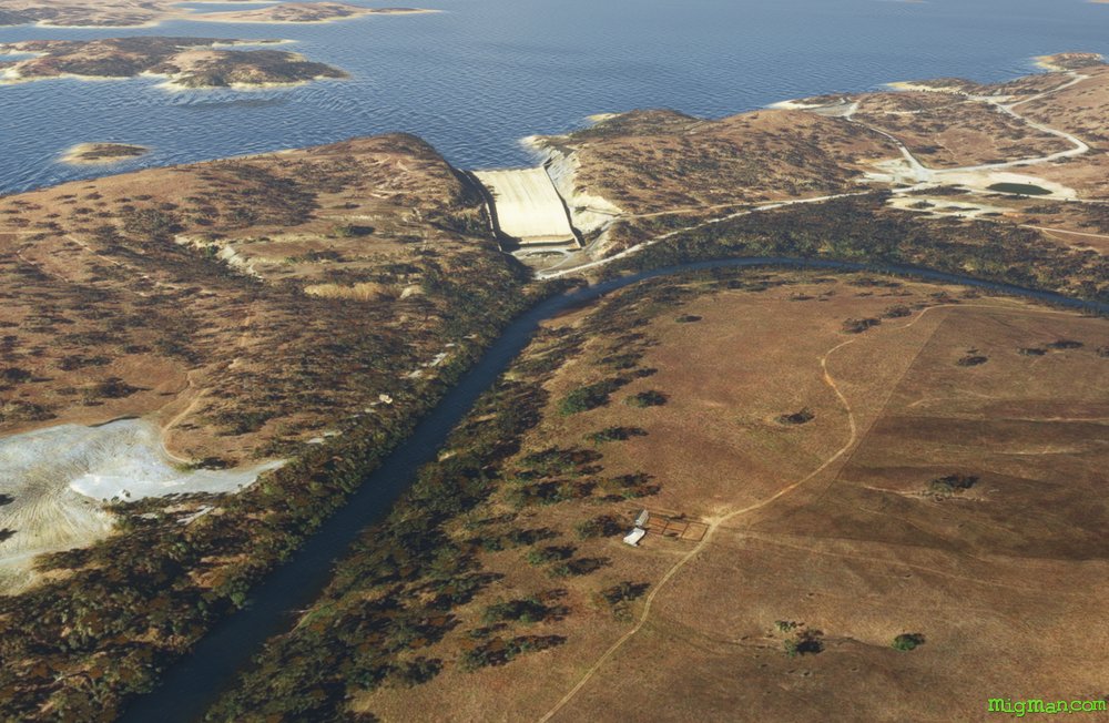
Wellington and Lake Burrendong
AboutDiscovered by John Oxley’s Lachlan River expedition in 1817 at the junction of the Bell and Macquarie Rivers, Wellington is the second oldest New South Wales settlement west of the Blue Mountains. Named after the Duke of Wellington, in 1823 the government established a settlement there with 12 cows and 40 sheep. The colony fell into some disrepair and was revived ten years later by the arrival of Lutheran missionaries. The man-made irrigation reservoir at Lake Burrendong was built over the period 1946-1967 and now holds more than three times the water of Sydney Harbour.
NOTAM: Wellington Airport YWEL runways 13 and 31 are inoperative as of May 2023 due to maintenance.
NOTAM: Wellington Airport YWEL runways 13 and 31 are inoperative as of May 2023 due to maintenance.
Australia
location_cityN.S.W. | Central West & Orana
flight_takeoffYMDG Mudgee
airline_seat_recline_extraAustralia 3
tagDam spotting
tagCanyon runs & Mach Loops
MacCabe Corner
AboutFrancis Peter MacCabe (1817-1897) surveyed three of the main rivers in New South Wales: the Murrumbidgee, Darling and Murray. MacCabe Corner is at the junction of South Australia, Victoria and NSW on the Murray River.
Australia
location_cityN.S.W. | Far West
flight_takeoffYWTO Wentworth
airline_seat_recline_extraAustralia 3
tagBorder Patrol
tagAiports
Wilcannia, Remote inland Port
AboutWilcannia is located in remote far NW N.S.W., about 425 nm from Sydney as the crow flies. It was a busy inland port in the country during the river boat era of the mid-19th century. Today it has a population numbering in the hundreds. You will find the town about 1 nm S of the airport, on the Darling River.
Australia
location_cityN.S.W. | Far West
flight_takeoffYWCA Wilcannia
airline_seat_recline_extraAustralia 3
tagBridges
You say Airana, I say Urana
AboutA small town of about 300 people, Urana was settled by the British in the 1850s. Urana derives from the Aboriginal word "Airana", meaning a temporary shelter.
Australia
location_cityN.S.W. | Riverina Murray
flight_takeoffYBEI Berrigan
airline_seat_recline_extraAustralia 4
Murrumbidgee to Murray, south and east of Balanrald
AboutFly out of Balanrald, where the Sturt Highway (after explorer Charles Sturt) crosses the mighty Murrumbidgee, down to the even mightier Murray!
Australia
location_cityN.S.W. | Riverina Murray
flight_takeoffYBRN Balranald
airline_seat_recline_extraAustralia 4
tagBridges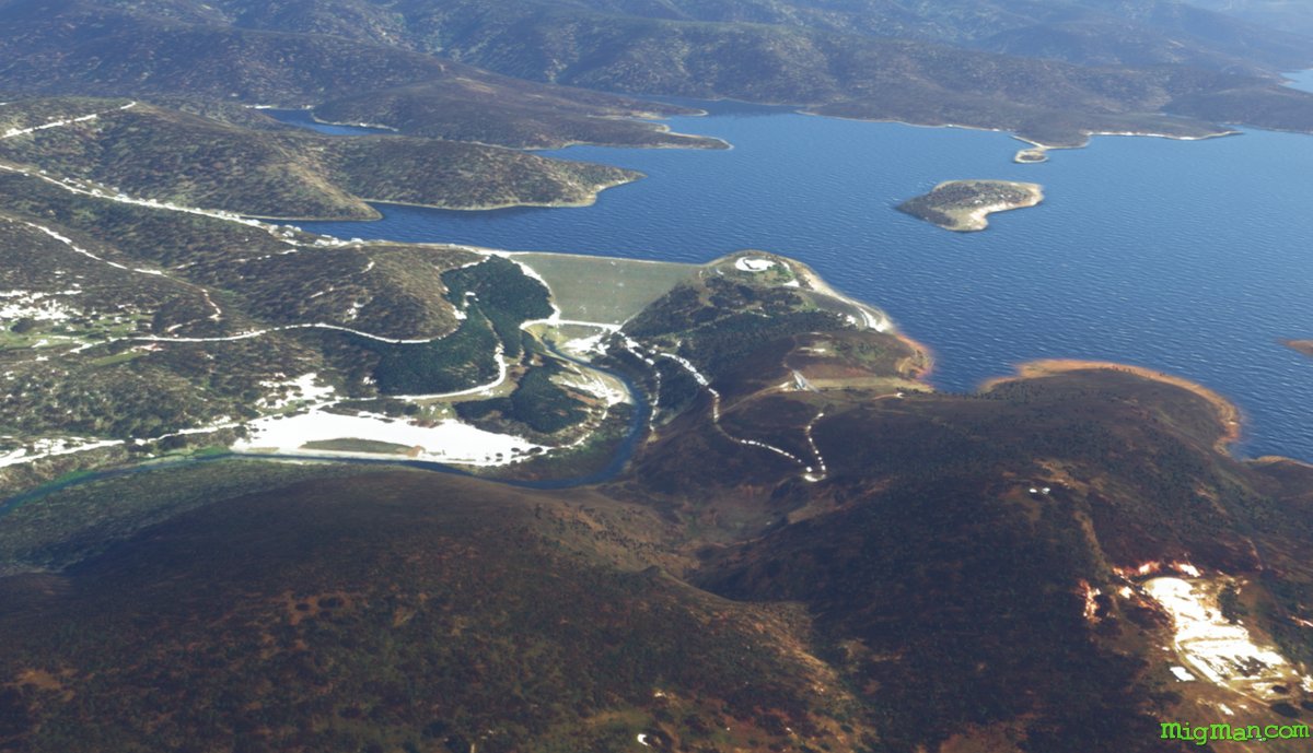
Lake Eucumbene
AboutLake Eucumbene was created as part of the Snowy Mountains Hydro scheme in 1958 and holds 9 times the capacity of Sydney Harbour.
Australia
location_cityN.S.W. | South East & Tablelands
flight_takeoffYCOM Cooma
airline_seat_recline_extraAustralia 4
tagDam spotting
tagAiports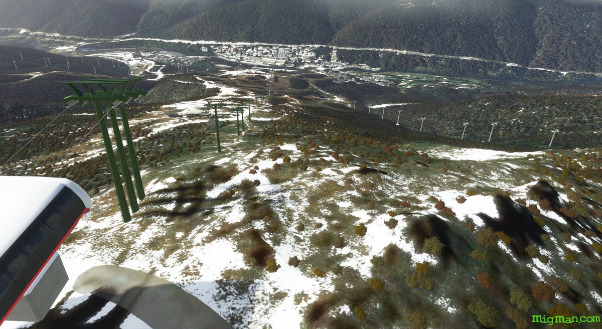
Thredbo, Perisher and Mt Kosciusko
AboutThredbo and Perisher are two of Australia's most popular ski destinations. While not the most dramatic peak, at 7,310 feet Mt Kosciusko is nonetheless Australia's tallest.
Australia
location_cityN.S.W. | South East & Tablelands
flight_takeoffYCOM Cooma
airline_seat_recline_extraAustralia 4
tagCanyon runs & Mach Loops
tagAiports
Lake Mulwala
AboutFly over Lake Mulwala, which is part of the mighty Murray river, and practice toucn'n'gos at Tocumwal Airport YTOC (4176 and 3939 ft, paved) and Berrigan YBER (4,214 ft, grass).
Australia
location_cityN.S.W. | Riverina Murray
flight_takeoffYCOR Corowa
airline_seat_recline_extraAustralia 4
tagBridges
tagAiports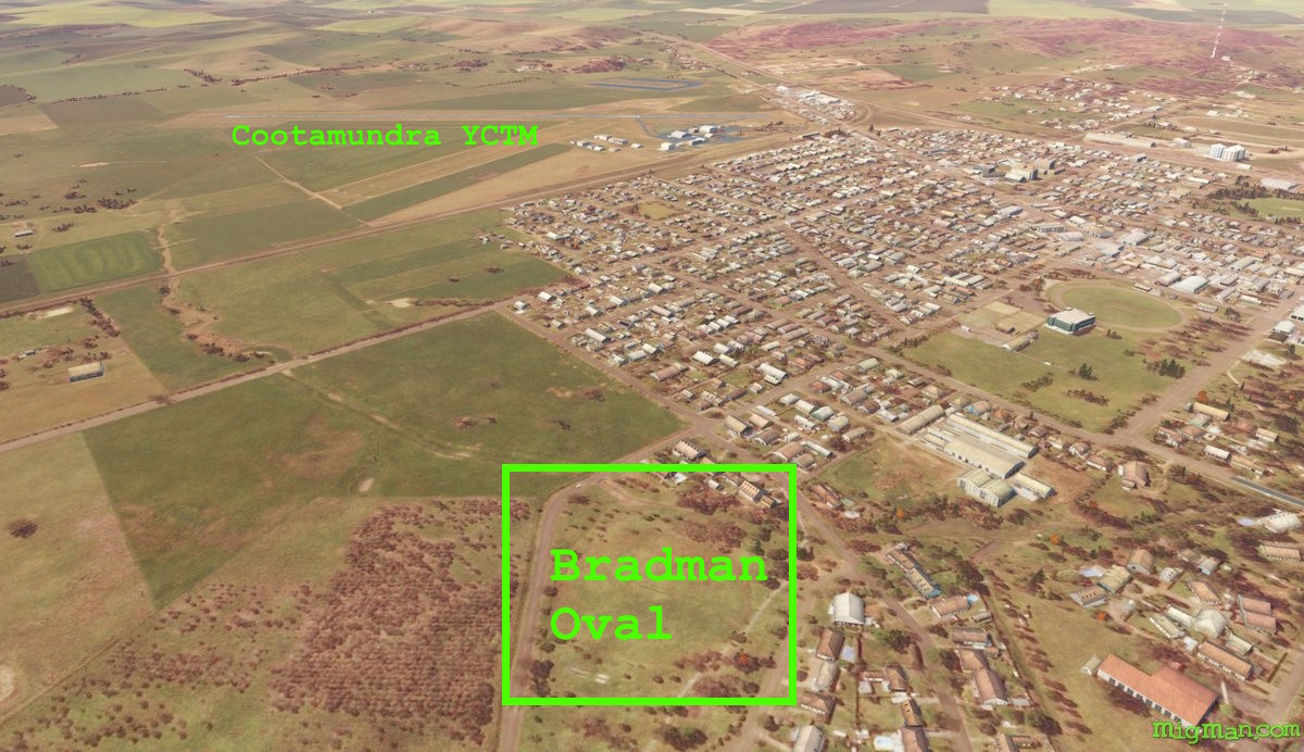
A Birdie for Bradman
AboutCombine your two passions of flying and golf in this trip! And let's not forget your 3rd Aussie passion, the noble game of cricket. Australia's most famous cricketer, Sir Donald Bradman was born in Cootamundra.
Australia
location_cityN.S.W. | Riverina Murray
flight_takeoffYCTM Cootamundra
airline_seat_recline_extraAustralia 4
tagAiports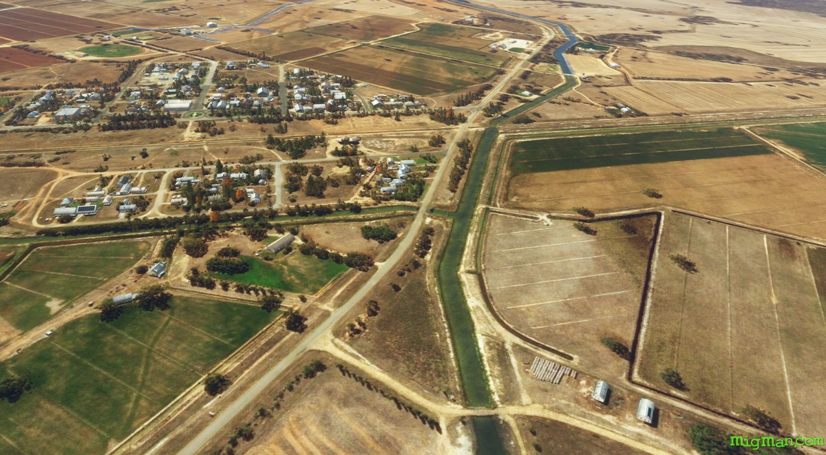
The Peppin Merino Affair
AboutEnglish sheep breeder George Peppin established a stud north of Deniliquin at Wanganella. He aimed to breed a variant which would thrive in Australia's dry conditions. A measure of his success is that about 70 per cent of Australia's merinos today are thought to be descendants of his flock!
Australia
location_cityN.S.W. | Riverina Murray
flight_takeoffYDLQ Deniliquin
airline_seat_recline_extraAustralia 4
tagBridges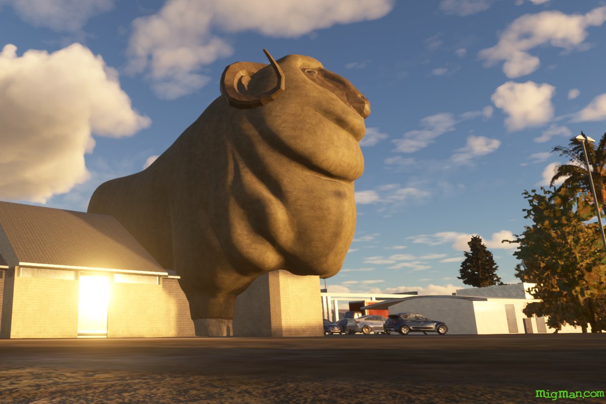
The Big Merino
AboutAustralia has been said to ride on the sheep's back, and when you see the Big Merino at Goulburn you will understand why! The locals call it 'Rambo', after an award winning ram from the Bullamallita stud. There is a multi-level gift shop inside Rambo and at night it's eyes cast an eerie green gaze over Goulburn. Nobody knows why.
Australia
location_cityN.S.W. | South East & Tablelands
flight_takeoffYGLB Goulburn
airline_seat_recline_extraAustralia 4
tagDam spotting
tagAiports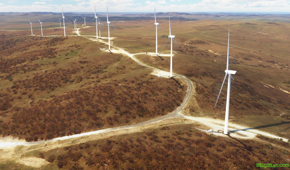
Goulburn to Lake George
AboutLake George is a great landmark for practicing your low level flight. Keep a weather eye out for the low level aviation hazard known as the "Wind Farm".
Australia
location_cityN.S.W. | South East & Tablelands
flight_takeoffYGLB Goulburn
airline_seat_recline_extraAustralia 4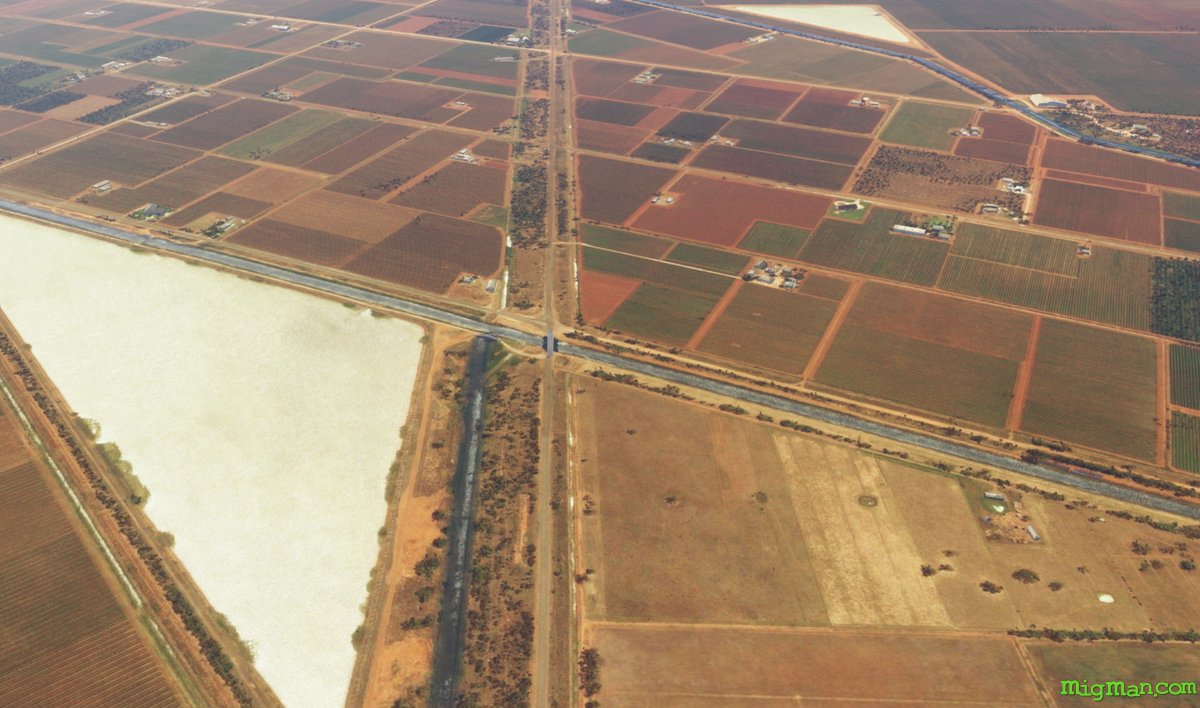
Griffith and the Post War Boom
AboutPost World War II, Australia took in immigrants from 30 European countries, the top three numerically being from Britain, Italy and Greece. Many from the latter two settled in the Riverina region and help spur the development of 'the food bowl of Australia', and their cultural heritage can be seen in much of the local architecture.
Australia
location_cityN.S.W. | Riverina Murray
flight_takeoffYGTH Griffith
airline_seat_recline_extraAustralia 4
tagArchitectural Wonders
tagBridges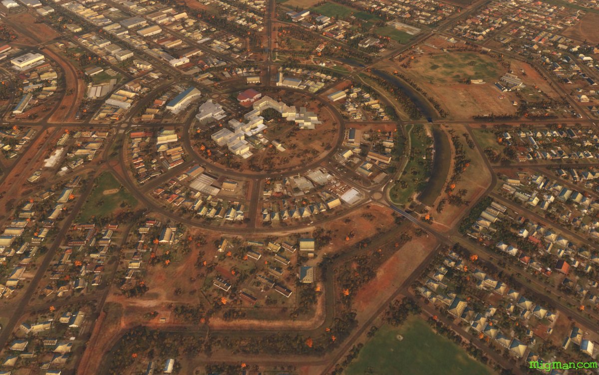
Griffith's Griffin and the Japanese Print Affair
AboutIf you've flown over Canberra in 'Australia 1' you may recognise the hand of architect Walter Burley Griffin in the layout of Griffith. Griffin designed Griffith in 1914, contemporaneously with his work on Australia's capital, Canberra. From 1901-06 he worked in Frank Lloyd Wright's office, practicing the 'Prairie School' of modernist design, which emphasised a break with history, as if that were desirable or even possible. Wright and Griffin parted ways with Wright in 1906 over the "Japanese Print Affair". Such are the conceits and foibles of 20th century 'isms'!
Australia
location_cityN.S.W. | Riverina Murray
flight_takeoffYGTH Griffith
airline_seat_recline_extraAustralia 4
tagAiports
Cryptic Crop Circles
AboutIn Australia the farmers regard crop circles as passe. Rather, they carve aides-a-la-navigation such as arrows pointing towards the nearest airport. Just another example of Aussie creativity and community spirit, making hay while the sun shines.
Australia
location_cityN.S.W. | Riverina Murray
flight_takeoffYHAY Hay
airline_seat_recline_extraAustralia 4
tagBridges
Albury and Lake Hume
AboutAlbury and Wodonga are sister cities sittinng astride the mighty Murray River on the N.S.W. and Victorian border. Lake Hume is a major source of irrigation water and hydro-electric power for the two states.
Australia
location_cityN.S.W. | Riverina Murray
flight_takeoffYMAY Albury
airline_seat_recline_extraAustralia 4
tagBorder Patrol
tagDam spotting
tagAiports
Bega & Bermagui
AboutBega is synonymous in Australia with a popular brand of cheese, the South East & Tablelands being a rich dairy producing region. The entire coastline in this region is breathtaking. Bermagui is probably derived from the aboriginal word permageua (canoe).
Australia
location_cityN.S.W. | South East & Tablelands
flight_takeoffYMER Merimbula
airline_seat_recline_extraAustralia 4
tagBridges
tagCoastal flight
tagDam spotting
Return to Eden
AboutVisit the most southern town in NSW and stray a few miles over the Victoran border to Mallacoota. You should have no problems as Victoria is mostly a friendly state.
Australia
location_cityN.S.W. | South East & Tablelands
flight_takeoffYMER Merimbula
airline_seat_recline_extraAustralia 4
tagBorder Patrol
tagBridges
tagAiports
Southern Gentry
AboutBowral, Berrima and Mittagong are at the junction of greater Sydney and the Southern Tablelands. The area is a favourite weekend destination for Sydney-siders with it's charming manors, wineries, antique shops and tulip gardens.
Australia
location_cityN.S.W. | South East & Tablelands
flight_takeoffYMIG Mittagong
airline_seat_recline_extraAustralia 4
tagBridges
tagDam spotting
tagAiports
Batemans Bay, Pearl of the South
AboutWhere the Clyde river flows into the Pacific Ocean, oysters thrive at Batemans Bay and this has become the basis of a thriving industry. About 10 miles west the Great Dividing Range rises out of the dense bush, forming an impressive backdrop to the golden beaches.
Australia
location_cityN.S.W. | South East & Tablelands
flight_takeoffYMRY Moruya
airline_seat_recline_extraAustralia 4
tagBridges
tagCoastal flight
Narooma
AboutWith the skyline dominated by Dromedary Mountain to the south, Narooma and surrounds are an idyllic combination of sandy beaches, lakes and mild weather.
Australia
location_cityN.S.W. | South East & Tablelands
flight_takeoffYMRY Moruya
airline_seat_recline_extraAustralia 4
tagBridges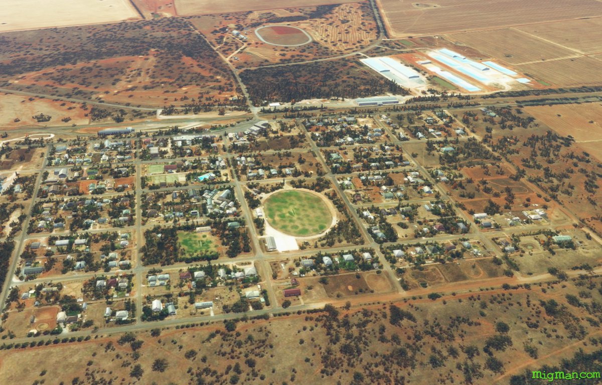
Leeton, Barellan, Yanco and Wimbledon
AboutEvonne Goolagong was a household name to several generations of Australians, being a World No.1 Tennis player, winning the French Open Singles and the women's singles at Wimbledon, 86 titles in all. Evonne was born in Griffith in 1951, third child of eight, and grew up in Barellan. Her father Ken was a sheep shearer. Leeton is a major centre in the Riverina and Murrumbidgee Irrigation Area and home to Yanco Agricultural High School, where generations of Australian schoolchildren have learned the science of the land.
Australia
location_cityN.S.W. | Riverina Murray
flight_takeoffYNAR Narrandera
airline_seat_recline_extraAustralia 4
tagAiports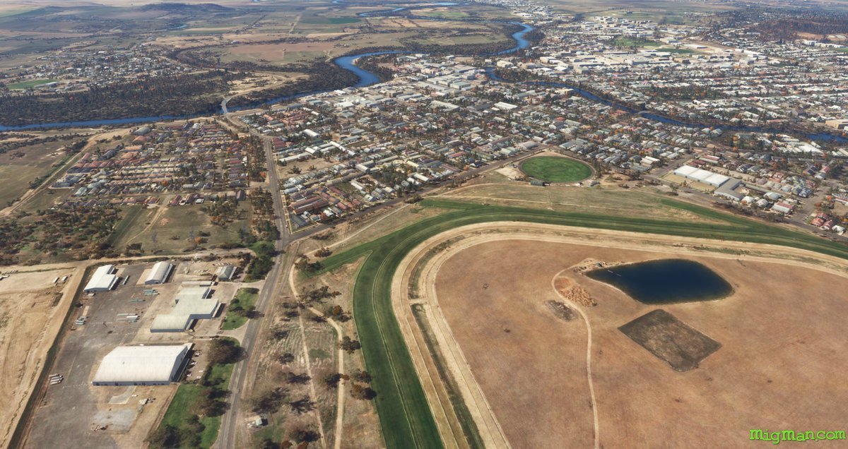
The Wagga Effect
AboutThe "Wagga Effect" refers to the disproportionate number of elite athletes who originate from Wagga Wagga. This is noteworthy because Australia is already disproportionately represented in elite sports, as well as in academic, musical and artistic achivement! It must be something in the water.
Australia
location_cityN.S.W. | Riverina Murray
flight_takeoffYSWG Wagga Wagga
airline_seat_recline_extraAustralia 4
Kapooka, Home of the Soldier
AboutBlamey Barracks in Kapooka Military Area is where all Australian Army recruits undergo basic training.
Australia
location_cityN.S.W. | Riverina Murray
flight_takeoffYSWG Wagga Wagga
airline_seat_recline_extraAustralia 4
Warbirds of Temora
AboutMore than 2,500 Royal Australian Air Force pilots were trained in the Tiger Moth at Temora between 1941-45. The warbird collection features Australian designed and built CA-13 Boomerang, CA-16 Wirraway, CA-27 Sabre Jet, Many of the warbirds are in flying condition, and you can also see the Cessna A-37B Dragonfly, Cessna O1-G Birddog, DH-115 Vampire, DH-82 Tiger Moth, English Electric Canberra, Gloster Meteor F.8, Lockheed Hudson, Ryan STM S2, Supermarine Spitfire Mk VIII and a Supermarine Spitfire Mk XVI.
Australia
location_cityN.S.W. | Riverina Murray
flight_takeoffYTEM Temora
airline_seat_recline_extraAustralia 4
Dog on the Tuckerbox
AboutThere is a dog on a tucker box, and it's nine miles out of Gundagai. The statue was first erected in 1926, and it is a tribute to the life of a 'bullocky', a bloke who steers a team of bulls who pull a bullock dray, usually laden with timber. This is the job my grandfather started at age 13. A 'tucker box' is a food container.
Australia
location_cityN.S.W. | Riverina Murray
flight_takeoffYTMU Tumut
airline_seat_recline_extraAustralia 4
tagBridges
tagDam spotting
tagCanyon runs & Mach Loops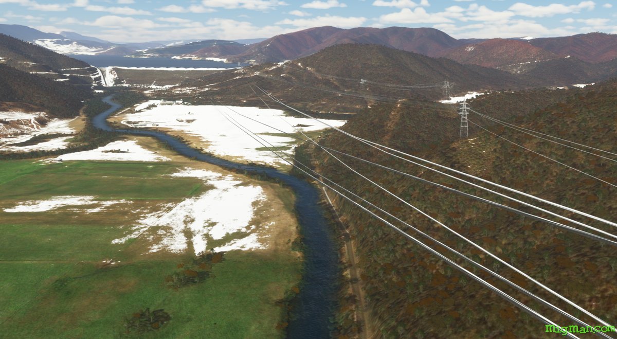
Snowy Mountains Scheme
AboutThis vast hydro-electric project was built in the 1930's and has 16 dams, 9 power stations, 80 km of aqueducts and 145 km of tunnels.
Australia
location_cityN.S.W. | Riverina Murray
flight_takeoffYTMU Tumut
airline_seat_recline_extraAustralia 4
tagDam spotting
West Wyalong by Drysdale
AboutWest Wyalong was immortalised in a 1949 painting by Australian Russell Drysdale. The painting captures the zeitgeist of Australian country towns, as it depicts a view down the main street past the pub at tea time.
Australia
location_cityN.S.W. | Riverina Murray
flight_takeoffYWWL West Wyalong
airline_seat_recline_extraAustralia 4