What is MiGMan’s World Tour?
Let me show you all the cool and fun places I've found in Microsoft Flight Simulator.
Make the entire world your playground as you get to know the local neighbourhood... in every country in the world.
These missions are designed for VISUAL flying.
So, forget about your autopilot, get your head on a swivel, your hand on the stick, and enjoy the fantastic scenery in Microsoft Flight Simulator.
The MiGMan's World Tour format
- Each flight can be completed in less than an hour.
- Take off and land at the same airport.
- Fly to prominent landmarks, such as airports, bridges, dams, mountain peaks, river mouths, prominent buildings, road intersections and more. These are the visual references that real pilots use.
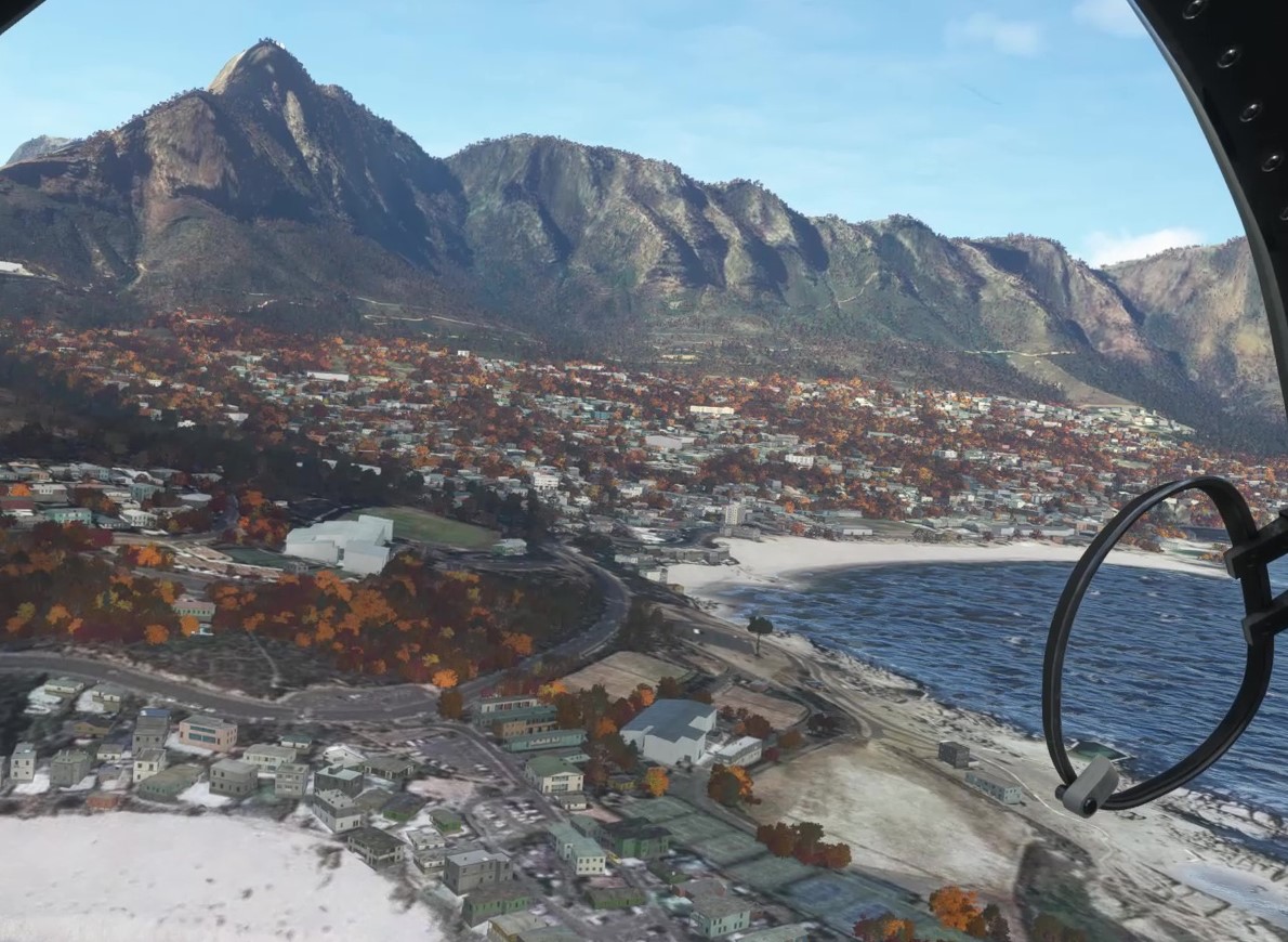
- Immense replay value. Your first flight in an area is pretty challenging, as you look for the landmarks. Subsequent flights reveal different kinds of fun as you 'know where you are going' and can spend more time enjoying the incredible scenery. Go to www.migman.com to see examples of this in Capetown and in Cardiff, where I spent an entire week flying one mission over and over!
- Every country you visit starts with a flight out of and back to the capital city.

Using just the two flight plans included in
Africa 4, I spent a fun-filled week exploring
Cape Town, South Africa. Some of my explorations lasted a few minutes, some an hour.
Check them out and get inspiration for your own flights.
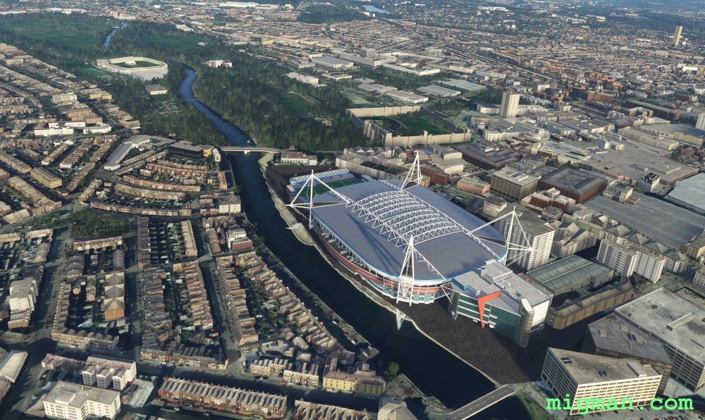
Back to the basics. Good old fashioned stick and rudder flying. Feel the wind in your hair, look out the window and enjoy the view!
Product range
25 flights in Algeria, Angola, Benin, Botswana, Burkina-Faso, Burundi, Cameroon, Cape-Verde, Central African Republic.
Choose your own aircraft, weather and time of day.
BUY NOW
26 flights in Chad, Comoros, Congo, Djibouti, Equatorial Guinea, Eritrea, Eswatini, Ethiopia, Gabon, Gambia, Ghana, Guinea
Choose your own aircraft, weather and time of day.
BUY NOW
24 flights in Ivory Coast, Kenya, Lesotho, Liberia, Madagascar, Malawi, Mali, Mauritania, Mauritius, Morocco
Choose your own aircraft, weather and time of day.
BUY NOW
26 flights in Mozambique, Namibia, Niger, Nigeria, Republic of the Congo, Rwanda, Sao Tome, Senegal, Seychelles, Sierra Leone, Somalia, Somaliland, South Africa, South Sudan, Sudan, Tanzania, Togo, Tunisia, Uganda, Zambia, Zimbabwe
Choose your own aircraft, weather and time of day.
BUY NOW
25 flights in Afghanistan, Azerbaijan, Bangladesh, Bhutan, Brunei, Cambodia, China, Hong Kong, India, Indonesia, Japan, Kashmir, Kazakhstan, Kuril Islands, Kyrgyzstan.
Choose your own aircraft, weather and time of day.
BUY NOW
25 flights in , Laos, Macau, Malaysia, Maldives, Mongolia, Myanmar, Nepal, North Korea, Pakistan, Philippines, Singapore, South Korea, Sri Lanka, Taiwan, Tajikistan, Thailand, Tibet, Timor-Leste, Turkmenistan, Uzbekistan, Vietnam.
Choose your own aircraft, weather and time of day.
BUY NOW
Asia Complete
Contains everything in
Asia 1 and
Asia 2, with 50 flights in Afghanistan, Azerbaijan, Bangladesh, Bhutan, Brunei, Cambodia, China, Hong Kong, India, Indonesia, Japan, Kashmir, Kazakhstan, Kuril Islands, Kyrgyzstan, Laos, Macau, Malaysia, Maldives, Mongolia, Myanmar, Nepal, North Korea, Pakistan, Philippines, Singapore, South Korea, Sri Lanka, Taiwan, Tajikistan, Thailand, Tibet, Timor-Leste, Turkmenistan, Uzbekistan, Vietnam and 2 volumes of illustrated briefings.
Choose your own aircraft, weather and time of day.
BUY NOW
Take a flight sim holiday in the blue waters and sunny islands of the Caribbean.
You will want to take these flights again and again. I know I do.
25 flights in Anguilla (UK), Antigua and Barbuda, Aruba (Netherlands), Bahamas (Abaco, Berry Islands, Bight of Acklins, Bimini Islands, Castaway Cay, Cat Island, Eleuthera, Exuma, Grand Bahama, Long Island, New Providence, San Salvador Island, The Bahamas), Barbados, Belize.
Map of the more than 700 locations featured in Caribbean Visual Volumes 1,2,3 and 4
Videos of the flights in this volume
BUY NOW
25 flight plans and 105 round trips in Federal Dependencies of Venezuela, Grenada, Guadeloupe (France), Haiti, Jamaica, Martinique (France), Monsserrat (UK), Nueva Esparta (Venezuela), Puerto Rico (USA), Saba (Netherlands), Saint Barthelemy (France), Saint Kitts and Nevis, Saint Lucia, Saint Martin (France), Saint Vincent and the Grenadines, San Andres and Providencia (Colombia), Sint Eustatius (Netherlands), Sint Maarten (Netherlands)
Map of the more than 700 locations featured in Caribbean Visual Volumes 1,2,3 and 4
Videos of the flights in this volume
BUY NOW
This package, free to purchasers of Caribbean Visual Volume 1, 2 or 3, rounds out the most thorough exploration yet of the Caribbean region in Microsoft Flight Simulator.
This library of Caribbean flights will guarantee you hundreds of hours of sightseeing fun when you add in the 700 plus locations and the ability to fly any aircraft and at any time of day or night, and in any weather!
Locations: Trinidad and Tobago, Turks and Caicos Islands (UK), and the U.S. Virgin Islands.
Contents:
- 7 .pln files
- 45 page Briefing pdf shows you step by step and in beautiful illustrations, how to enjoy 22 round trips
- Installation Guide pdf
- User Guide | Shows you how to load the flights, setup your weather and time, and tips on visual navigation
Map of the more than 700 locations featured in Caribbean Visual Volumes 1,2,3 and 4
BUY NOW
Caribbean Complete
This is the most in-depth and complete exploration of the Caribbean in Microsoft Flight Simulator.
This library of Caribbean flights will guarantee you hundreds of hours of sightseeing fun when you add in the 700 plus locations and the ability to fly any aircraft and at any time of day or night, and in any weather!
Contents:
- All the contents of Caribbean 1, Caribbean 2, Caribbean 3 and Caribbean 4.
- 83 .pln files
- Complete Briefing pdfs showing all the visual references in beautiful illustrations.
- Installation Guide pdf
- User Guide | Shows you how to load the flights, setup your weather and time, and tips on visual navigation
Map of the more than 700 locations featured in Caribbean Visual Volumes 1,2,3 and 4
BUY NOW
25 flights in Abkhazia, Albania, Armenia, Belarus, Belgium, Bosnia-Herzegovnia, Bulgaria, Croatia
Choose your own aircraft, weather and time of day.
BUY NOW
26 flights in Czech Republic, Denmark, Estonia, France, Georgia, Germany, Greece, Hungary, Iceland, Ireland, Italy
Choose your own aircraft, weather and time of day.
BUY NOW
25 flights in France, Kosovo, Latvia, Liechtenstein, Lithuania, Luxembourg, Macedonia, Malta, Moldova, Monaco, Montenegro, Netherlands, Northern Cyprus, Norway, Poland, Portugal, Pridnestrovie, Romania
Choose your own aircraft, weather and time of day.
BUY NOW
26 flights in Russia, San Marino, Serbia, Slovakia, Slovenia, Spain, Sweden, Switzerland, Ukraine, United Kingdom and Vatican City.
Choose your own aircraft, weather and time of day.
BUY NOW
Europe Complete
Coming soon.

The 25 flight plans included give you 42 different flights as illustrated in the 244 page Briefing Notes pdf. Explore Bahrain, Cyprus, Northern Cyprus, Dubai, Egypt, Iran, Iraq, Israel, Jordan, and Kuwait.
Choose your own aircraft, weather and time of day.
BUY NOW
The 25 flight plans included give you 70 different flights as explained in the 207 page Briefing Notes pdf. Explore Lebanon, Oman, Qatar, Saudi Arabia, Syria, Turkey, United Arab Emirates and Yemen.
Choose your own aircraft, weather and time of day.
BUY NOW
Middle East Complete
The 50 flight plans included give you 112 different flights as explained in the 447 page Briefing Notes pdfs. Explore Explore Bahrain, Cyprus, Northern Cyprus, Dubai, Egypt, Iran, Iraq, Israel, Jordan, Kuwait, Lebanon, Oman, Qatar, Saudi Arabia, Syria, Turkey, United Arab Emirates and Yemen.
Choose your own aircraft, weather and time of day.
BUY NOWStandard Edition for PC
The standard edition is designed for flight sim fans who have a bit of experience and enjoy the freedom of the genre. They also value their time and like to jump straight into a flight knowing they're going to see something interesting.
Fly the way you want to fly!
- Drive to your local airport and hire a plane (ANY plane that's in your MSFS hangar)
- Fly any time of day or night
- Fly in any weather
- Either start on the runway, engine running and ready for take-off (the default setting) or do a complete startup and taxi.
- Fly around and look at stuff
- Fly with your friends in multiplayer (all players require a copy of the product)
- Fly 'Top Gun Maverick' style valley runs
- Follow rivers, land on lakes and dams
- Return the plane in one piece and get your security deposit back
- Drive to McDonalds
- Drive home and post your snapshots to your blog
A perfect day out.
Now use the MiGMan’s World Tour flights and Microsoft Flight Simulator to do that all over the world!
Here are the main differences as compared to the game edition:
- Your sim preferences are not changed in any way and you can adjust any setting during the flight.
- Fly any aircraft that you own.
- Choose the weather.
- Choose the time of day, or night.
- Extensive illustrated route guides are included in .pdf format
Standard Edition: Package Contents
- 25 .pln files which you can install anywhere on your PC
- 200 plus page BRIEFING pdf with step by step, beautifully illustrated, instructions for every flight
- Installation guide pdf
- User Guide | Shows you how to load the flights, setup your weather and time, and tips on visual navigation
Supporting material
The material listed here is accessible at
www.migman.com with any internet-connected device. I recommend using your mobile phone or a tablet in your home cockpit for even more immersion.
- Hints and tips
- Step by step visual aids to each flight provided in a mobile friendly format
- Videos of each flight, in different aircraft
- Videos of locations
- Videos of airports
- Airport maps
Standard Edition: System requirements
- Microsoft Flight Simulator in Standard, Premium or Deluixe edition
- Windows PC
- Internet connection to download the package
Standard Edition: Which aircraft is it for?
Any aircraft that you own in Microsoft Flight Simulator.
Recommended aircraft: ultralights, general aviation aircraft, helicopters, amphibious, turbo props, fast jets.
Your aircraft type | Your time per flight | Pros and cons |
---|
General aviation aircraft, any light aircraft. Cruise 60-120 knots. | 45 minutes to 1 hour. The preferred way to sight see in an aircraft. |
Helicopters. Cruise speed 80-120 knots. | 45 minutes to 1 hour. Helicopters are really enjoyable for checking out scenery features. You can get up close and personal with the scenery AND land anywhere! |
Amphibious Aircraft. | Many of the missions include water features for you to land on. Fly to a luxury resort, land on the lake. Have a cup of tea. Come back and resume your flight. What a great way to spend an afternoon! |
Fast turbo props. Cruise speed 150-250 knots. | 30 to 45 minutes. A great way to see a lot of scenery, quickly! | TOP GUN PILOTS. Fast jets with a cruise speed of 300 knots plus. | 15 to 20 minutes. Many of the flights can be flown as low-level speed runs. Check out the videos! |
Airliners. | Airliners are not the best for sight seeing flights, although it is possible. |
Standard Edition: How to fly
The Standard Editions are geared towards the sim pilot who wants more control of his aircraft and the simulation.
How to start:
- Choose a country, city or airport to fly in.
- If you don't have the particular volume which contains the mission, the BUY links are here
- Click on the mission you want to fly
- Read the flight plan and look at the pictures. They show what you will see at each waypoint
- If there are any videos showing the flight, they will be listed under the related country, locale or airport page.
- e.g. Algeria or Algiers or Houari Boumediene DAAG
- Run Microsoft Flight Simulator on your PC.
- Load the specified flight plan into Microsoft Flight Sim. e.g. Africa Visual Vol.1/algeria-DAAG-to-DAAG-VFR-210912.pln
- Open the VFR MAP or look at your in-cockpit map to see the direction of the firwst waypoint.
- Take off.
- Fly towards the first waypoint..
- Check out the photos to help you identify the lake / building / bridge. An example.
- Take a few happy snaps!
- Repeat for waypoint 2 and 3.
- Land.
Microsoft Marketplace Editions for XBox and PC
Enjoy the
player assistance available in the Microsoft Flight Simulator engine such as waypoint markers, airport markers, assisted takeoff and landing, no crashes and more.
Aircraft

The Cubcrafters NX Cub is the default aircraft in these Microsoft Marketplace Editions because of these characteristics:
- Excellent visibility out of the cockpit
- Carefree handling, being quite stable down to about 40 knots
- Tripod landing gear, making it easy to land
- Large moving map on the dashboard
PC owners can fly any aircraft by:
- Selecting 'Developers Mode' in options
- Loading the flight
- Using the Aircraft Selection menu available at the top left of your screen
Available titles
Microsoft Marketplace Edition: System requirements
- Microsoft Flight Simulator in Standard, Premium or Deluxe edition
- Windows PC or XBox
- Internet connection to download the package
Microsoft Marketplace Edition: Start your flight
Run Microsoft Flight Simulator
Click on ACTIVITIES
Scroll to the right and click on CUSTOM
Click on a flight
Start the flight
HINT: To toggle the VFR MAP press V on a PC.
HINT: To toggle the NAV LOG press N on a PC.
Microsoft Marketplace Edition: End your flight
Land at the airport you took off from and turn the engine off.
Piper NX Cub

Turn the engine off with the KEY located on the right hand side of your cockpit panel.
Piper NX Cub
Any aircraft from the Piper Cub series is great for sightseeing, with excellent all round visibility and easy handling in the air. They have been around since 1938, and so are tried and tested!
For aspiring fighter pilots, they have the cool factor in that there is nobody sitting next to you! The instructor or passenger sits behind you.
The XCub series have a moving maps right there in the cockpit, and these aircraft are included in the Standard, Premium and Deluxe editions of Microsoft Flight Simulator.

Asobo XCub
History
The original Piper Cub and most of it's derivants are tail-draggers. Tail draggers present a couple of difficulties:
- They are difficult to taxi and in the early stages of takeoff because the view ahead is very restricted
- They tend to nose-over easily with the application of brakes
Enter the NX Cub. N for nose-wheel.

Cubcrafters NX Cub
The NX retains all the good features of the Cub and removes the two problems listed above.
Just after takeoff. I have the NAVLOG window open on the left, and am steering in the general direction of the magenta line on the moving map display.
Navigating in the Piper NX Cub

Cockpit layout in the XCub, with the NAVLOG open.

Close up of the moving map.
There is a lot of useful information here. From top left:
- WPT | Waypoint name: POI1 (Point of Interest 1)
- BRG | Compass direction to steer to get to the waypoint. In this case: 34 degrees, roughly north east.
- DIST | Distance to the waypoint. In this case 5.3 miles
So, accordingly I:
- Turn the plane roughly north-east
- Make sure I am between 1000 and 1500 feet altitude
- Bring up the NAVLOG (default key is "N")
- Check whether I am seeing something like the image in the NAVLOG

Yes!
Look left and right
In most aircraft the view forward and down is partially blocked by the engine compartment.
The solution then is to approach the target at an angle and use the superior left and right views.
Note: These images were taken in the Zlin Shock Ultra, a more rugged version of the Cub series. It has no moving map in the cockpit.

Even though it has good visibility, the view straight ahead is partially blocked by the engine. So here I am
planning my turn so I approach the waypoint from one side.

I am slightly left of the waypoint, and can clearly see the landmark out the right side.
The recon images in MiGMan’s World Tour were taken between 1000 and 1500 ft altitude. So, initially, approach them from that altitude range in order to recognise them.

Approaching right, looking left. Geometric shapes with contrasting colours are fairly easy to see.
Most of the waypoints in MiGMan’s World Tour can be reached by following a road, river, coastline or valley.

Approaching right, looking left. The colour of bodies of water depend on time of day and weather, sometimes easy to see, sometimes not! In this case the sharp and simple geometry make the ponds stand out.

Approaching right, looking left.
Why not fly over the aiport? Because that airport is over the border, and we don't want to cross borders in MiGMan’s World Tour. However we can certainly use it as a reference point. The NAVLOG says the intersection is 0.7nm south east of the airport so, locate the airport visually and flt slightly south.
This waypoint is hard to see!
This next waypoint is at the most difficult level in MiGMan’s World Tour because it is hard to see.
I have included landmarks like this because:
- they are often airports, which are always worth knowing the location of in general aviation
- in real life airports can be hard to see! Even though I know this route very well I still often have to circle this particular waypoint 2 or 3 times before I can see the airport. This is all part of the fun in visual flying!

Approaching right, looking left.
You can see I have circled the waypoint to lower and lower levels until I could see the airport. It was worth it!
In fact I landed there and had a cup of tea with the friendly staff. They don't get many visitors.

Approaching right, looking left. This landmark was chosen because of it's contrasting colour with the surrounding landscape.
Look left and right Plan your turns
Every type of aircraft presents different challenges in regard to seeing what is around you.
Here are some examples with suggested solutions. This is all part of the fun of flying!
Look left and right Plan your turns
A plane can't turn like a skateboard. It turns in arcs, or circular patterns.
Also, most aircraft don't have great visibility directly ahead because the nose hides the ground. To see objects below you generally have to look left or right.
Let's use this to our advantage!
So, in this example, to see the football field indicatd in the diagram and turn right we will:
- Approach slightly from the left
- Bank to the right
- Look right
How to think ahead and get a great view of those landmarks!

Approaching the RIGHT turn. Keeping the object on our RIGHT

Approaching the first LEFT turn. Keeping the object on our LEFT

Looking LEFT

Still banked LEFT as we approach another LEFT turn

Looking LEFT
F/A-18E Superhornet: Aircraft with HUD
The HUD (Heads Up Display) is great for showing flight data as you look straight ahead.
However it can make it difficult to spot subtle scenery objects. Here are a few examples with suggestions as to how to get around the problem.

As you can see, or rather can't see, the water treatment ponds are very hard to spot through the HUD.

Solution? Move your head to the left.

Similarly here, the road junction is quite difficult to see.

Solution? Move your head to the right, or as seen here, fly without the cockpit view. This solution is particularly popular with home cockpit builders, who display their instruments outside the simulator.

Get your head in the game any way you can!
Assistance Features
Microsoft Flight Simulator has a host of features to help people enjoy flying and sight-seeing with no hassle!
In the MiGMan’s World Tour GAME EDITIONS these features are turned on as much as is possible.
In the regular editions the settings default to the player's preferences and are totally adjustable.
Aircraft Systems
Automixture, Unlimited Fuel, Aircraft lights, Gyro Drift
Navigation Aids
Waypoint Markers
When you are 2000 feet from the waypoint, the Assistance Pointer will automatically switch to the next waypoint.

Waypoint Markers

Waypoint Marker in Microsoft Flight Simulator as seen from the external view.

Waypoint Marker in Microsoft Flight Simulator as seen from the cockpit view.
Taxi Ribbons
Landing Ribbon
Smartcam Mode
Piloting
Take-off Auto Rudder, Assisted Yoke, Assisted Checklist, Assisted Landing, Assisted Takeoff, AI Radio Comms (ATC), AI Anti-Stall, Auto Trim, Assisted Controller Sensitivity.
User Experience
Air Traffic Control (ATC): Panel, Message log, Voices
Checklists
NAV LOG
Open the NAV LOG by pressing "N"

The NAV LOG in Microsoft Flight Simulator.

Using the NAV LOG to confirm that you are at the right landmark.
VFR MAP
Open the VFR MAP by pressing "V"

The VFR MAP in Microsoft Flight Simulator.
AI piloting in cursor mode
Failure & Damages
No Crash mode, No Stress Damage, No Engine Stress Damage, No Icing.
Notifications
Assistance with: Piloting & Controls, Aircraft System, Flying Tips,
Objectives, Software Tips.
POI Markers
Points of Interest (POI) can be indicated by arrows and icons in the sim environment.
The FLIGHT ASSISTANT menu allows you to select Fauna, Airports, Cities, or Landmarks.
In this example I have opened the FLIGHT ASSISTANT menu, selected LANDMARKS, and clicked on SET AS DESTINATION for the Temple Mount landmark.

In this example I have opened the FLIGHT ASSISTANT menu, selected LANDMARKS, and clicked on SET AS DESTINATION for the Temple Mount landmark.
Gameplay Assistance
ATC Panel, Delegate Control when using mouse view, HUD visible in the Chase view, HUD visible in the Cockpit view, Auto Logbook update, Assisted Elevator, G Suit.