Sims which use Satellite imagery in the scenery
AboutAdds scenery of Flying M Ranch and Ranger Creek to Microsoft Flight Simulator 2002.
precision_manufacturingLago
airline_seat_recline_extraScenery
airline_seat_recline_extraSatellite ImageryAboutAdds scenery of high altitude Bryce Canyon Airport and its surroundings to Microsoft Flight Simulator 2002.
precision_manufacturingLago
airline_seat_recline_extraScenery
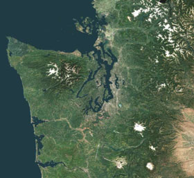
airline_seat_recline_extraSatellite ImageryAboutAdds scenery of Diamond Point airfield in the state of Washington to Microsoft Flight Simulator 2002.
precision_manufacturingLago
airline_seat_recline_extraScenery
airline_seat_recline_extraSatellite ImageryAboutThe promotional video from PC Aviator gives a good indication of where terrain mesh and mapping was at in 2004 for Microsoft Flight Simulator 2004. "Seattle and 30,000 Square Miles (76,000 sq km) of Spectacular Surrounding Areas of The Pacific Northwest and Washington State. ... MegaCity Technology brings out the finest real-world detail in the city down to the level of you being able to see vehicles on highways and sandtraps on golf courses."
precision_manufacturingAerosoft Australia
precision_manufacturingPC Aviator
airline_seat_recline_extraScenery
airline_seat_recline_extraSatellite ImageryAboutNew York is a VFR pilot's dream. The clarity of the scenery adds subtle depth to the flight. As well as the urban terrain there is enough surrounding countryside to keep you entertained. The documentation alone makes this product an exception to current publishing practice. Every aid necessary, in terms of maps, Approach Plates and Airport Diagrams, is given to encourage you to explore this product the way it is meant to be used.
precision_manufacturingAerosoft Australia
precision_manufacturingPC Aviator
airline_seat_recline_extraScenery
airline_seat_recline_extraSatellite ImageryAboutAfter a 14 year hiatus Microsoft re-envisioned their flagship IP. A combination of Bing satellite mapping, cloud storage, Azure cloud computing, photogrammetry, atmospheric physics modelling and many other bespoke software technologies have delivered a quantum leap in the flight sim experience. The next decade looks to be the best yet for flight sim fans!